

AUSTIN, TEXAS, April 24th, 2023 — Introducing Land id™, the future of property mapping and land identity. Land id™ provides real estate professionals, landowners, and anyone with an interest in land with unprecedented levels of property information, unlocking the full potential of any property. Every piece of land, parcel, or property has a constantly evolving identity. Whether it’s acreage or land ownership, contours or soils, water access or frontage, every property is unique — and all these elements combine to create a distinct land identity. Land id™ brings this identity to everyone.
At United Country, we’ve been using MapRight - now Land id™ - for the past 7 years. With Land id™, our brokers are able to easily create best-in-class maps to showcase all our properties, embed them on our website and share those maps with prospective buyers. The combination of powerful and easy to use mapping tools with the most comprehensive property data available means that we can produce highly effective property maps that are a critical part of our listing acquisition and property selling process.”
Dan Duffy, CEO, United Country Real Estate.
Since 2014, MapRight has been the choice of real estate professionals and landowners alike, providing market leading property mapping and land identity solutions available on both web and mobile platforms. Land id™ continues this heritage with an elevated vision to take property mapping and land identity to the next level. With Land id™, you can not only access the most comprehensive property and land data available but also easily create and share interactive maps with stunning visualizations, providing a deeper understanding of the properties and lands you love.
In 2022, Land id™ maps were shared to over 3 million unique recipients and each map was viewed for an average of 5 minutes, 11 seconds per person.
The viewing times of the maps our customers create are unheard of compared to other marketing channels and materials. For a real estate professional, a Land id™ map is the single most effective way to highlight property value to both acquire and sell listings."
Steve Roberson, Founder and CEO, Land id™.
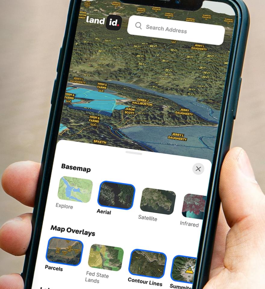
Land id™ serves the needs of both real estate professionals and landowners. With the recently launched Discover plan, Land id™ offers landowners, buyers and the land curious a market leading solution for understanding property and land identity in an affordable package. Land id™ Discover subscribers can leverage the new Land id™ mobile app to browse properties and see property ownership and boundaries on over 150 million properties across the entire United States. In addition to ownership information, the Discover plan provides access to a broad array of property attributes including legal description, property ID (APN) and tract numbers, acreage, land use, school district, building attributes, existing mortgage information, and property type — to name only a few. The most recent tax information is also provided, including last assessed year, tax amount, tax code area, and total calculated value, and properties can be easily searched by address, APN number, landowner name, or latitude and longitude coordinates.
Additionally, users can combine property data with other mapping layers and overlays to help gain a better understanding of any property — including water features, wetlands, FEMA flood plains, soil types, topo lines, transmission lines, city and county lines and much more. With the Land id™ mobile app, all property information and mapping layers are available offline and with built-in satellite GPS tracking a user can see his or her location on the map in proximity to property boundaries, buildings, fencelines or anything on the map.
Whether you are a real estate professional, a landowner or simply curious about land and land ownership, Land id™ provides a range of solutions to meet your needs. Here’s what Land id customers have to say about the solution:
Land id™'s sharing features have been a game-changer for our team. The app allows us to easily share property maps, notes, and listing information with clients, giving them all the information they need to assess a property. This has enhanced our ability to showcase properties, allowing us to better serve both buyers and sellers.”
Steve Bruere, President of Peoples Company
One thing I really appreciate about Land id™ is how user-friendly it is. The interface is intuitive and easy to use, whether you’re a seasoned professional or just starting out in the land brokerage business. Plus, the way it presents complex mapping data in a visually appealing format is just fantastic.”
Jeramy Stephens, Broker/Partner, National Land Realty
As a devoted real estate expert, I’m always on the hunt for cutting-edge tools that help me work more efficiently and serve my clients better. That’s why I’m so excited about Land id™. The app has completely changed the game for me in land brokerage.”
Dan Murphy, Broker/Owner, M4 Ranch Group
This is one of the best investments you’ll ever make.”
Tom Smith of Tom Smith Land and Homes
Land id™ Discover is available for download in the Apple App Store and Google Play Store, and is available for purchase on the Land id™ website and the Apple App Store as a monthly or annual subscription for an introductory price of $14.99/month or $79.99/year (56% savings).
Land id™ Pro is available for $49.99/month or $399.99/year (33% savings). Land id™ Pro Unlimited with unlimited map creation is available for $79.99/month or $799.99/year (17% savings).
Visit id.land for more information.
About Land id™
Land id™ is the leading provider of land identity™ and interactive property mapping applications for real estate. Land id™ solutions are used by professionals across multiple industries including land, residential and commercial real estate brokerages, property appraisals, agricultural farm and ranch management, forestry, building and development, government, engineering and renewables.
Continue Reading
Luxury on the Slopes
By Land id
In real estate, value isn’t just about where a property sits—it’s about the location of features and amenities, too!

Sell More, Sell Smarter With Land id™
By Land id
Becoming a leading agent in your market means delivering results and differentiating yourself–at every step. This is a challenge in the hyper-competitive real estate market, but the good news is that Land id™ can help. In a recent survey, 8 of 10 real estate professionals agreed that Land id™ helped transform and grow their business.


Explore Private Parcel Data & Property Boundaries
Download the Land id™ app & try for free
