

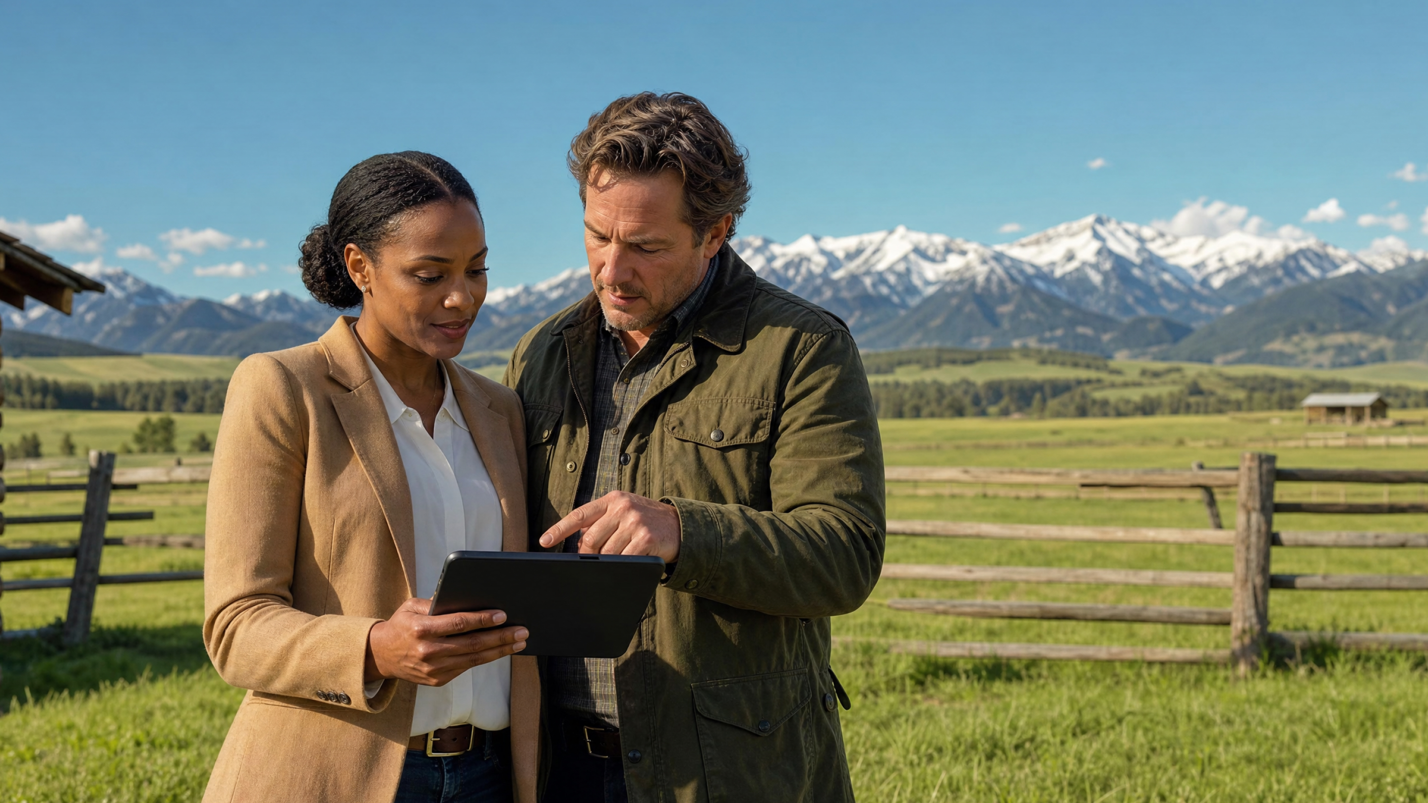
Today's rural land market draws buyers with sharper intentions than ever. Some want to profit from a working ranch or commercial farm. Some want property to divide and resell or develop. Some want five acres to build on and get out of the city.
They already know what they want the land for. What land buyers want to know is whether a particular property can deliver it.
That's where your property research as a land and ranch agent comes in. Here are the most frequently asked questions potential buyers have about a land or ranch purchase, and how to get those answers quickly using Land id.
Key Takeaways
- Land buyers typically ask due diligence-related questions to verify that the property can meet their intended use without hidden costs or legal restrictions.
- Soil potential, neighboring land, use restrictions, buildability, access, utilities, and natural resources are the seven areas every land buyer will probe.
- Use Land id to show your expertise and answer questions quickly by pulling critical property data layers into a single, interactive visualization.
- Share your research before you make the drive to save time and match buyers to right-fit properties faster.
1. Will the Land Work for My Goals?
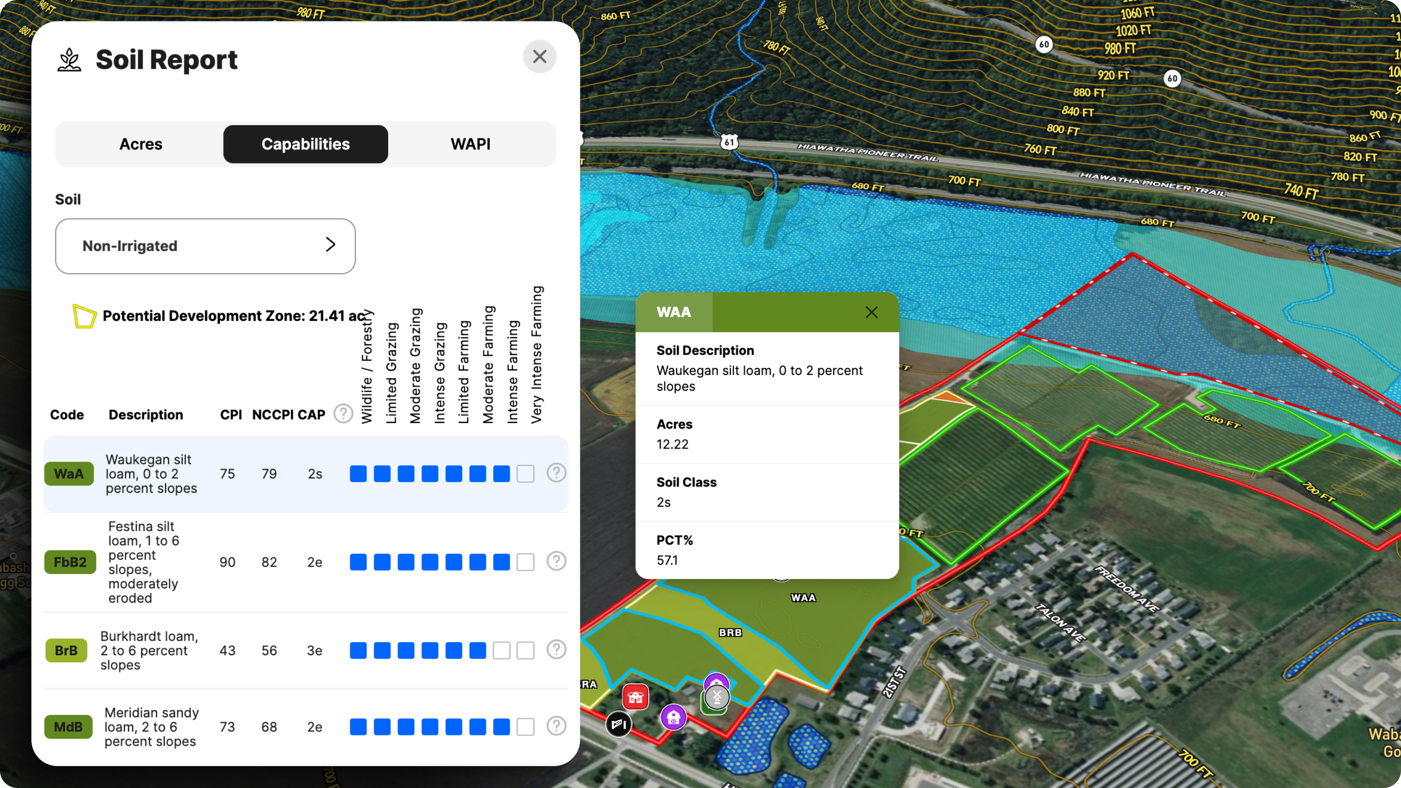
The physical characteristics of land, including terrain and soil quality, significantly influence its usability and development potential.
Land id's parcel search and overlays let you display property lines, soil classifications, FSA/Farm Service Agency boundaries, and contour lines/elevation on a single interactive map the moment a buyer reaches out.
As soon as the call comes in, pull up the parcel in Land id and get ready to field questions about property details:
- For building a home or structure—Turn on the high-res aerial basemap and Contour Lines layer to assess topography and elevation. Use the Oil Wells layer to check for oil and gas lines that could prohibit building plans.
- For agricultural land—Soil quality can affect whether the land can support building foundations, grow crops, or handle septic systems. Turn on the Soils layer to show soil type and drainage class.
- For growing and harvesting timber—Turn on the Infrared basemap to identify harvestable forest areas.
- For recreational use—Turn on the Infrared basemap and apply the Conservation Easements, Wilderness Areas, and FEMA Floodplain overlays to get an idea of restrictions, adjacent accessible land, or water features.
A potential land owner who can see their vision laid out on an actual parcel moves faster. That first conversation sets the tone—and gives you a chance to show off your expertise quickly. Don't wait for the appraisal to start building this picture.
2. What's Going On With the Neighboring Property?
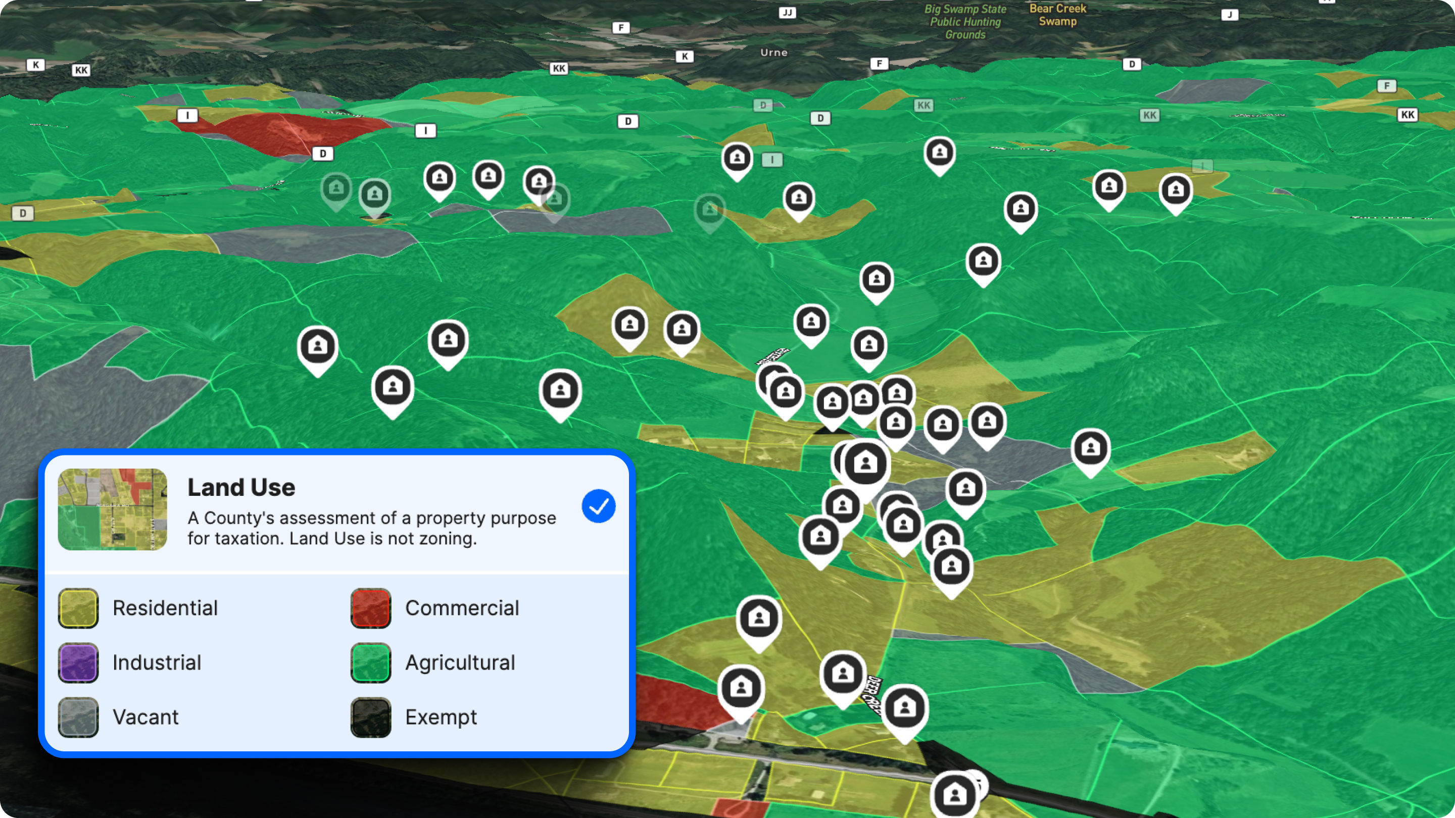
What's happening just beyond the fence line can make or break a land purchase. The surrounding area's development potential can significantly influence land value.
Before a showing, use Land id to pull up adjacent parcels and get a read on ownership and land use.
- A neighbor zoned for commercial or industrial use can mean increased noise, traffic, or environmental restrictions that affect your buyer's plans.
- Agricultural land next door looks appealing on paper but may come with seasonal activity, equipment hours, or odors a buyer hasn't anticipated.
- Sloped terrain on adjacent land can send water runoff onto the parcel—a drainage issue that's expensive to fix after closing.
- Adjacent vacant land might be the site of a planned development, meaning buyers can say goodbye to those idyllic views and hello to population growth.
In Land id, tap any parcel to see who owns the land. Click “Search Owner Portfolio” to see if they own any other property. Turn on the Land Use overlay to see how adjacent parcels are used or intend to be used.
3. Are There Any Land Use Restrictions?
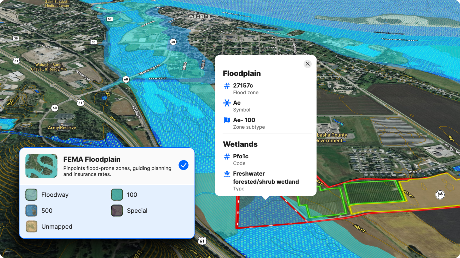
Land use questions derail more land purchases than almost anything else. A buyer who wants to run a commercial operation, build a guest house, or subdivide a portion needs to know what's legally permitted so they can evaluate the property's value—before they fall in love with the acreage.
Zoning regulations determine the permitted uses for a piece of land, whether for commercial, residential, agricultural, or other purposes. Formal zoning data is available through county records or the local planning office. Building codes set requirements like minimum lot sizes, setbacks, and height limits—all of which affect what a buyer can actually do with the land. Many counties also publish long-term development plans online, which can reveal how areas might be rezoned and significantly impact future value.
For general land use, three things to check in Land id before every showing:
- Land Use Overlay—Check the county’s assessment of a property's purpose based on taxation.
- FEMA Floodplain Overlay—Surfaces floodplain boundaries instantly, across any county, without a separate call to the county office.
- Wetlands layer—Flags wetlands designations that can restrict development or require permitting.
Toggle on both layers, send the prospect the map link, and talk through the property insights.
4. Can I Build on the Land?

Buildability is one of the first things buyers want to understand, and one of the last things sellers prepare for. Soil composition, slope, septic feasibility, and local building restrictions all factor in—and a buyer who's serious about building will want specifics, not approximations.
Before a showing, here's what to do in Land id:
- Turn on the Contour Lines layer to assess slope and drainage patterns. Steep grades limit options and increase construction costs. Surfacing this early sets honest expectations.
- Check the FEMA Floodplain Overlay to confirm whether any portion of the footprint is in a restricted zone.
- Use the Georeference tool to overlay a survey or plat image on the map if you have it. That extra layer of specificity is a credibility asset in the conversation.
- Use the Measurement tool to assess costs related to building roads and utilities, among other development needs.
- Turn on 3D maps for a life-like spatial sense of terrain and elevation.
- Visualize potential for land division using the Cut tool.
For buyers prioritizing a build, also flag whether a perc test has been done. A perc test is essential to determine if the soil can support a septic system. Soil that won't support a septic system can be a dealbreaker—and it's better for them to know it upfront.
5. How Do You Get There—And What Happens in Flood Season?
Access questions matter more on rural land than almost any other property type. Is there a deeded easement? Does the road wash out in winter? Are there low-water crossings that flood? These aren't hypothetical concerns for someone who's going to live or work on the land.
If you can speak with the previous owner before the showing, do it. Their knowledge of seasonal access issues, neighbor agreements, and road maintenance history is worth more than anything in a county record.
Document what you learn directly in your Land id map as annotations. When you share the map link with a buyer, those notes travel with it—so they're not calling you for context you've already gathered.
6. What Utilities Does the Property Have Access To?
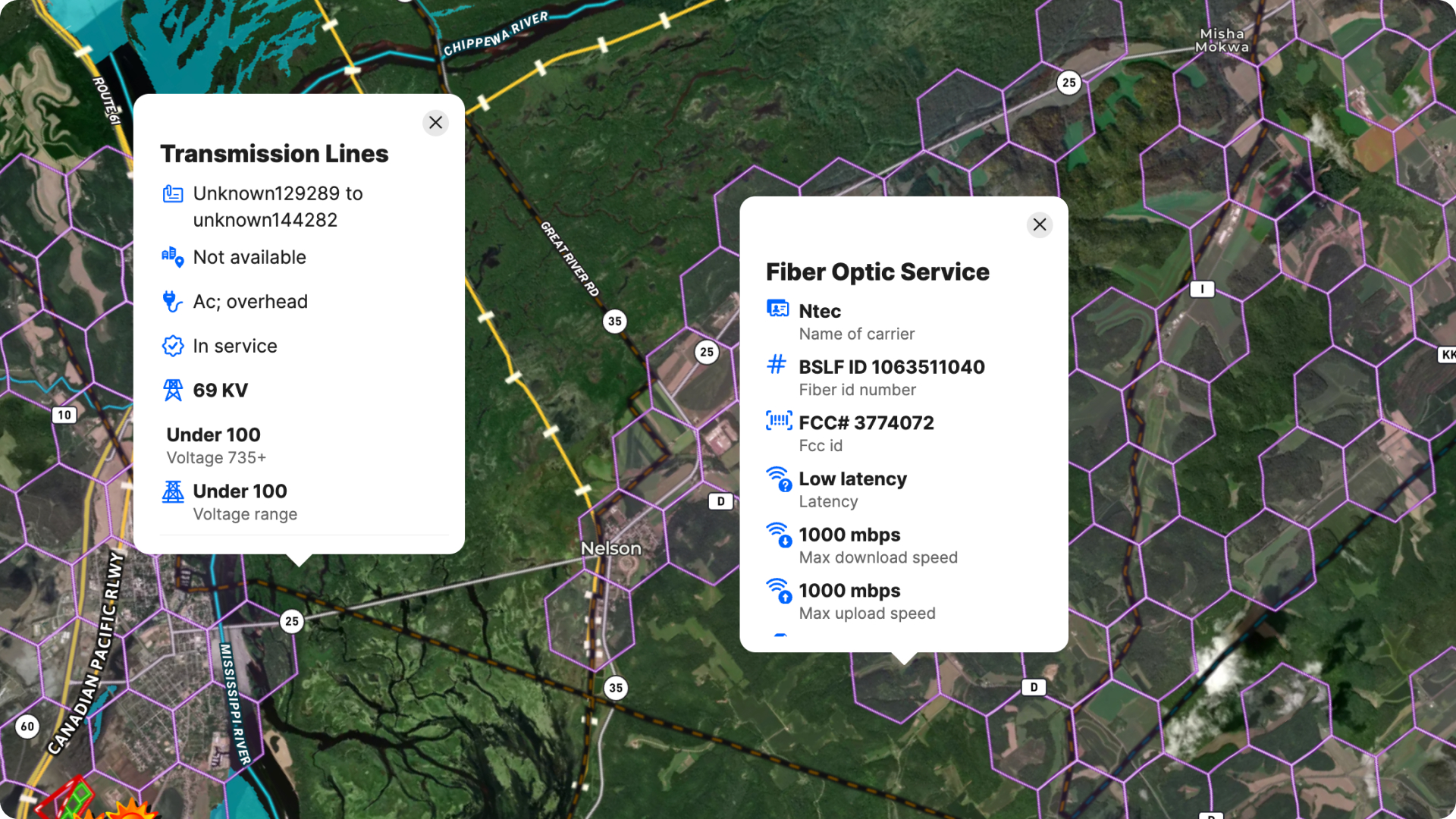
Power lines don't necessarily mean power service. Septic access isn't guaranteed. And in rural areas, internet connectivity is one of the most underrated deal factors in the market.
Having basic utilities in place, such as water, electricity, and sewage systems, is crucial when purchasing land, as the absence of these services can lead to major additional costs and time for installation.
Before a showing, verify:
- Water—Check for existing well systems, or see if it’s possible to add a well, by toggling on the Water Wells overlay, which pulls data from state agencies.
- Power—Turn on the Transmission Lines layer. Confirm whether power lines near the property are serviceable or shared agricultural infrastructure. These aren't the same thing.
- Internet—Use the Fiber Optic Service layer to look into fiber availability in the area. The prospective buyer should be prepared to use a satellite connection if no fiber is available.
7. What Natural Resources Come With the Land?
For land and ranch real estate transactions, natural resources are part of due diligence—not a bonus topic. Buyers will ask.
Easements and mineral rights must be identified as they may affect the use and value of the property. Start with what comes with the land. Timber rights, water rights, and mineral rights don't always transfer with a surface sale—and in many rural transactions, they've already been severed from the surface estate. Know the ownership history. Know what's been split off. If you don't, your buyer will find out at closing, which is the worst possible time.
Other factors to surface before the showing:
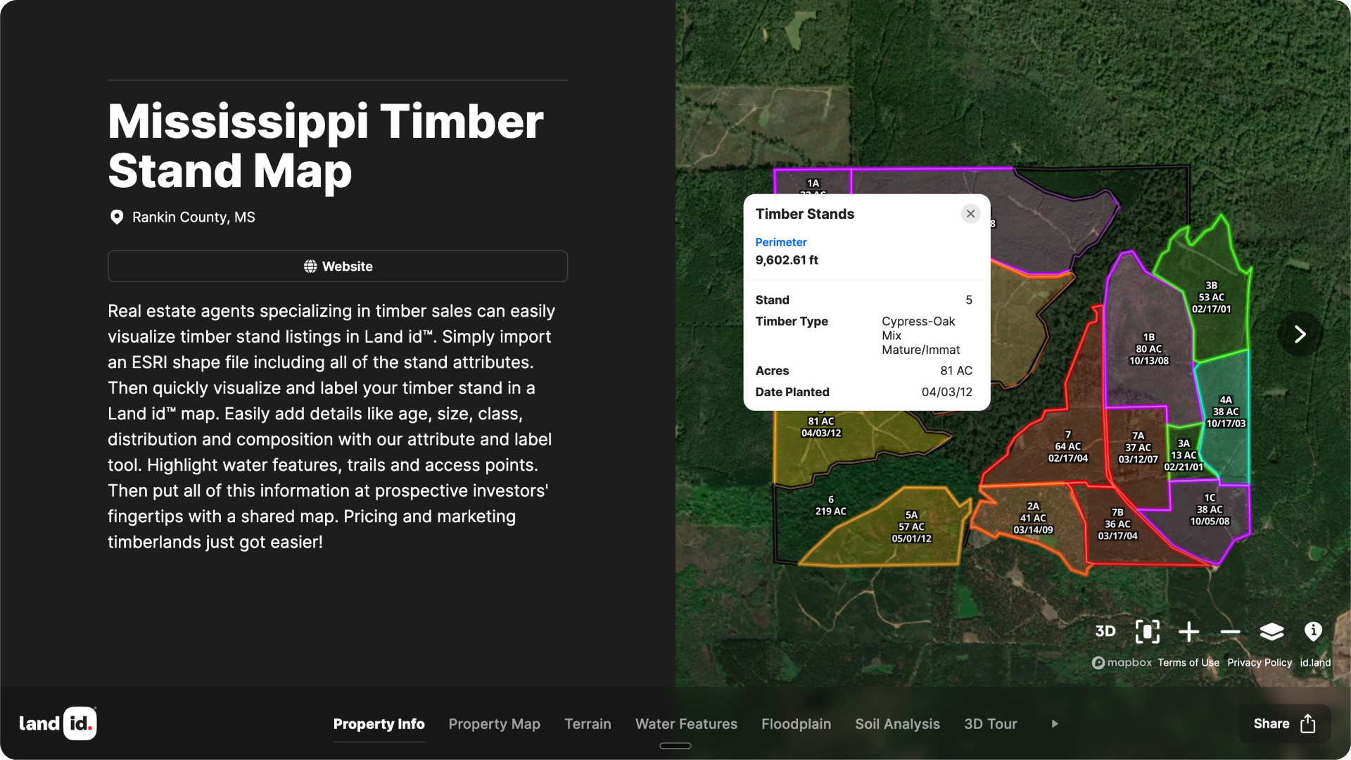
- Timber—Is there a timber stand with harvestable value? What permits or restrictions apply?
- Conservation easements—Check for existing easements that restrict development or resource extraction. In Land id, turn on the Conservation Easements layer to see recorded easements on or near the parcel.
- Environmental restrictions—Note nearby wetlands that could affect intended use or require permitting.
The agents who handle these questions quickly, with specifics, are the ones buyers trust the next deal to.
Don't Just Tell Them. Show Them.
The agents who win and close more land listings aren't always the ones who know the most. They're the ones who can communicate what they know quickly, in a way buyers can actually understand and act on.
Land id consolidates parcel boundaries, 3D property maps, ownership data, soil classifications, FEMA floodplain, contour lines, aerial imagery, and dozens of other data layers into a single interactive map you can build in minutes and share via text or link before a buyer ever sets foot on the property.
The lesson is: When it comes to selling or buying land, the information you have is only as valuable as your ability to put it in front of the right person at the right moment. Land id is how you can do it.
FAQs
What information should I have ready before a land showing?
How do I find out if land has floodplain or wetlands issues?
What's the best way to answer a buyer's access question?
How can I tell if a rural property has reliable internet access?
How do I research mineral rights on a rural property?
Catch Deal-Breakers Early
Save time and avoid expensive mistakes. Use Land id to evaluate deal-killing constraints before you leave your desk.
Continue Reading
Alyssa Toohey
Off the Map & In Person: The Land id Team Gets Together

By Land id
The Land id team came together in Montana for collaboration, connection, Big Sky views, PBR, Yellowstone, and plenty of memorable moments.

How Land id Works for Residential Agents
By Land id
Learn how Land id helps residential real estate agents visualize location, uncover property context, and market listings with greater impact.


Explore Private Parcel Data & Property Boundaries
Download the Land id app and try for free.
