


In its simplest form, A deed is a legal document transferring ownership rights from one party to the next. Many deeds dating back to the 1800s are still in use today; so while it will define the property's boundaries, it doesn’t usually do so in plain English. Luckily, we now have access to 21st-century deed plotting software - so translating ancient documents into usable data takes a fraction of the effort.
Deed plotting involves mapping out a land parcel’s boundaries based on the specifications of the deed(s). Deed plots hold many similarities to surveys; they can identify boundaries, existing structures and human-made features. However, survey and deed plots are not interchangeable.
To plot a deed, the appraiser will analyze a deed’s metes and bounds, which describe the land’s limits based on natural landmarks and human-made structures.
For example: N 17° E, 520 feet to a stake in William's line.
Metes give us the distance and direction of straight lines between two points, while bounds are less specific. A bound could be a waterway, road, rock, building or any number of other markers. Metes and bounds come in handy for defining large or oddly shaped properties. Accordingly, you can often find metes and bounds in many of the deeds for farms, ranches and other large parcels of land.
What Should Deed Plotting Software Do for You?
Though it’s always advisable to use a software system for deed plotting, it’s not always necessary to learn a new program. Land id’s (formerly MapRight) GIS mapping software is an incredibly powerful deed plotting tool, and navigating our app doesn’t require an advanced degree in 17th-century legal documents. You may be wondering, can a mapping tool really fulfill the role of deed plotting software? In short, yes. The catch? There are some capabilities the software must possess:
Area Measurements
With a perfectly rectangular parcel of land, you may not need anything more than your fourth-grade math prowess to calculate the area. However, sometimes the shape illustrated in a deed looks more like an inkblot yanked out of a Rorschach test than anything else, especially when rivers and roads make up boundaries. With properties like that, deed plotting software will be your greatest ally.
Calculating an organic shape’s area can be daunting, but with the right software, it doesn’t have to be. Deed plotting software should allow you to enter the metes and bounds, i.e., the angles and distances, then create a map of the property lines and corners automatically. Assuming there are no call errors and the intersections all match up, the program should then calculate the area for you - simple as that.
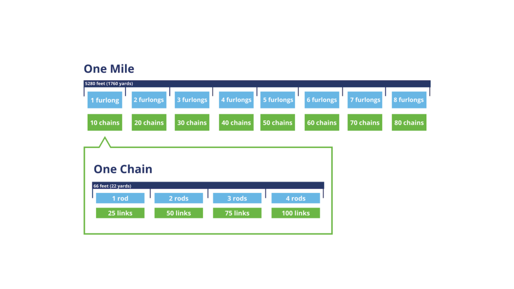
Units of Measurement
Land law uses different measurement units than most people are familiar with. Some of the most popular are based on Gunter’s Chain, a measuring device created in 1620 by astronomer and mathematician, Edmund Gunter. In this system, ten square chains equals one acre, and 6400 square chains equals one mile.
We can’t choose what measurement units a deed contains, but deed plotting software should allow you to enter measurements in multiple units and even convert measurements to the units of your choice. This is especially helpful when sharing a map of the land with people who aren’t well-versed in deed terminology; not everyone knows how long 80 chains is, but most people can wrap their minds around a mile.
Finding Call Errors
A call is the compass direction and the distance of a line in a metes and bounds survey. When a deed contains an incorrect legal description of a property, it has what we refer to as call errors. If they aren’t handled carefully, even minor issues in a deed are capable of causing nasty complications. Inaccuracies can cause mild hiccups, such as building a fence on a neighbor's land, or they can be much more devastating. Since taxes and loans are based largely on a property’s value, even small call errors can cause serious financial impacts; lenders don’t like mistakes, even if they were made 200 years ago. Worse still, is developing a property with call errors. If you build a home for yourself on what turns out to be a neighbor’s property, you may have built your neighbor a house.
That's why we have a Priority of Calls: guidelines for surveyors to follow when creating new land parcels and retracing old parcels of land. These guidelines help determine which calls to follow when deeds are incorrect or contradict one another (ex. Douglas’s deed says he owns the two acre stretch at the edge of his property, but Rosa’s deed says she owns it). The Priority of Calls can be used to help settle these disputes by clarifying what calls are most important. The closer to the call is to the top of the list, the more influence it has.
- Lines actually run on the ground and with proven evidence:
This assumes the surveyor placed the original line where it was intended. - Monuments called for in the description:
Natural monuments are less likely to move than human-made monuments, so they come before artificial monuments in the Priority of Calls. - Adjoiners:
Adjoiners are boundary descriptions based on neighboring properties (ex. Land bound by Stuart on the West, and Williams on the East). With adjoiners, the older deed will trump a newer one. - Courses:
Without monuments or adjoining properties, the next highest priority will be bearings and distances. - Calls for Area:
The lowest priority call is area.
We can easily identify call errors by utilizing deed plotting software. All you have to do is enter in the calls, and the software maps out the land for you. Deed plotting software will show if the boundaries don’t line up, monuments are not located where the deed specifies, and if the stated area doesn’t match the calculated area. Software that allows users to create layered maps are especially useful for finding call errors. With a layered map, you can overlay the deeds of surrounding properties to ensure that your parcel doesn’t overlap.
Deed Plotting With Land id®
All deed plotting software should calculate area and find call errors - but great deed plotting software doesn’t just give you data, it makes that data usable. With Land id®, users can overlay the deed map with soil reports, topographic maps, grazing patterns, building plans, etc. Our georeferencing tool lets you overlay a survey or site plan on top of an aerial map, and you can adjust the opacity to see every layer at once.
With these tools, not only can your map show boundaries, but it can show the qualities and features of a property as well. We believe deed plotting doesn’t need to be complicated, and you’ll see that reflected in our software. With our easily identifiable icons (which are great for plotting monuments), even a cartography novice can interpret deed maps.
If you're in need of deed plotting software, look no further! Land id’s GIS technology can do everything deed plotting software does and more - with a fraction of the effort. If you’re as excited as we are about deed plotting, start your 7-day free trial now! We’ll provide you with all the tools you need.
FAQs
Continue Reading
Craig Rowe
How Factory-Built Housing Can Reshape America’s Housing Market
.png)
By Land id
The U.S. housing industry’s decade-plus-long inventory challenge could see its first true sign of resolution should the 21st Century Road to Housing Act become law.

Craig Rowe
Can Refurbishing Schools Help Solve Housing Issues?
By Land id
Old public schools are becoming apartments as enrollment drops. See why school-to-apartment conversion is adaptive reuse's fastest-growing niche.


Explore Private Parcel Data & Property Boundaries
Download the Land id app and try for free.
