


If a client texts you a pin drop and asks "Can you tell me anything about this land?"—how fast can you answer? For real estate agents, especially those working with rural properties, large acreage, or any property where a street address may not exist, mastering parcel number lookup is essential for delivering fast, accurate answers.
This guide covers parcel number lookup methods, tools, and workflow for real estate agents. By understanding and leveraging parcel number lookup, you'll streamline research, avoid costly mistakes, and provide clients with reliable, up-to-date property information—giving you a competitive edge in every transaction.
Key Takeaways
- An Assessor's Parcel Number (APN) is tied directly to the tax roll and official parcel boundaries—more reliable than a postal address, especially for rural and agricultural properties.
- APN lookup supports every phase of a deal: pre-screening leads, verifying lot size before listing, catching red flags before escrow, and building client-facing property maps.
- Free county websites work for single-county searches but fragment quickly across jurisdictions. Land id is far more user-friendly and standardizes parcel lookup for agents working across county lines.
- Parcel data is a starting point, not a substitute for title, survey, or legal advice.
What Is a Parcel Number & Why Do Real Estate Agents Use It?
A parcel number—also called an APN, Parcel ID, Property ID, or PIN—is the unique identifier a county assessor assigns to every piece of taxable real estate. Parcel numbers are typically listed on property tax bills, deeds, and appraisal reports.
Land agents, ranch brokers, investors, and residential agents use APNs to pull ownership records, legal descriptions, acreage, assessed value, zoning, and sale history from comprehensive parcel data in official tax and assessment databases faster and more precisely than searching by address alone.
The reason APNs matter: addresses change. A corner lot might share a street number with an ADU. New construction often has no USPS address at all. Rural parcels frequently have no formal address whatsoever. The APN is the one identifier that ties directly to the legal parcel polygon—the actual boundary on record at the county.
How to Look Up a Parcel Number: County Websites vs. Land id
Real estate agents can look up parcel numbers through official government records or on a property data platform like Land id.
Finding a Parcel Number on a County Website
County assessor or tax collector websites are the primary digital source for accurate parcel data. Most counties have free, public GIS mapping tools available on county assessor or recorder websites. Most counties publish parcel data through their assessor or recorder office. The basic workflow:
- Locate the relevant website by searching online for “[County Name] assessor” or “[County Name] property appraiser."
- Find the APN from an MLS sheet, tax record, or prior closing statement. Enter it into the county's search tool.
- If you don't have the APN, some counties support a reverse search by property address, owner name, or subdivision/lot.
The disadvantages of county-based APN lookup have to do with consistency and user experience:
- County systems vary dramatically—some require exact APN formatting with dashes, others drop leading zeros.
- Reverse lookup isn't always available.
- Map viewers are often downright frustrating on mobile.
- If you work across more than one or two counties, maintaining separate logins and learning different interfaces gets old fast.
Finding a Parcel Number in Land id
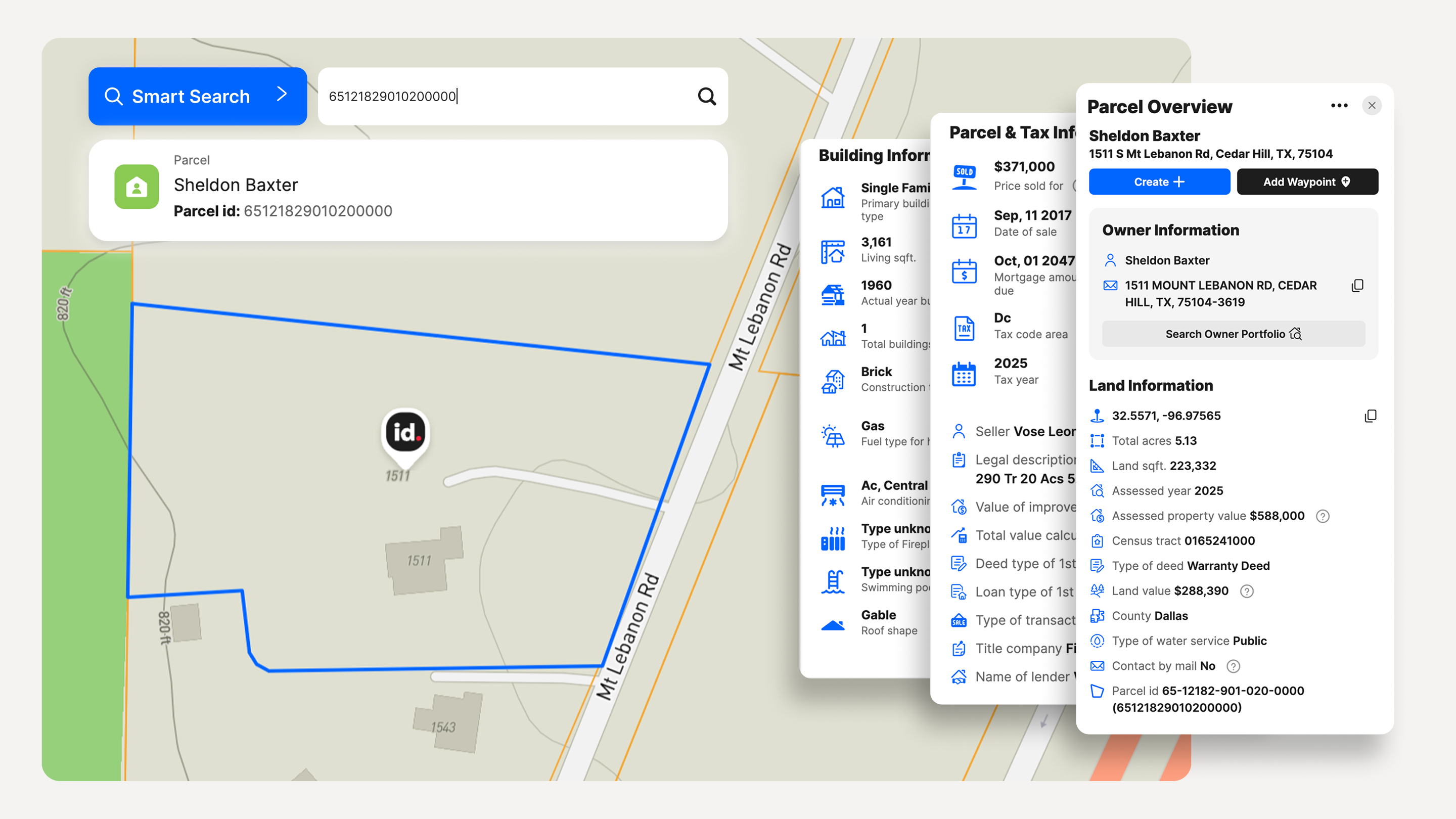
Land id's AI-powered Smart Search covers more than 150 million U.S. properties across all 50 states. Type an APN, address, owner name, or lat/long coordinates—whatever you have—and Land id resolves it to the right parcel instantly. You can also click directly on a map for instant access to a data-rich card of parcel information.
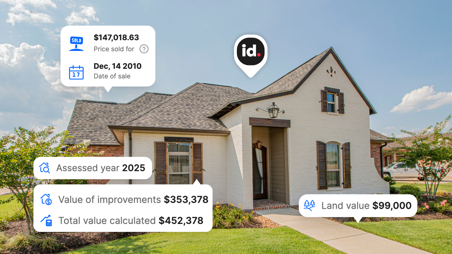
Once you're on the parcel, you see the APN, ownership information, acreage, legal description, assessed value, last sale data, and more—all in one place, without toggling between county portals.
Where Parcel Lookup Fits in a Real Estate Agent's Workflow
APN lookup isn't a one-time move. It shows up at every stage of a deal, making it a critical first step in your workflow.
Pre-Screening Leads
Before you drive to a listing, run the parcel. Verify that the property and ownership actually match what the client described. Check for legal access via recorded easements on the map. Get a realistic picture of acreage, flood risk, and zoning before committing your day.
You have a couple of options on how to run this pre-screening. Free county websites work fine for limited use—for example, if you only need to look up APNs on occasion, operate in one or two jurisdictions, are usually on a desktop computer, and don't mind learning different interfaces for each.
As soon as you're working across county lines—or need land data like FEMA floodplain, wetlands, soils, or contour data alongside your parcel search—a unified property data and mapping platform saves significant time. Land id handles format normalization automatically and presents a consistent interface regardless of which county you're researching.
Listing Prep
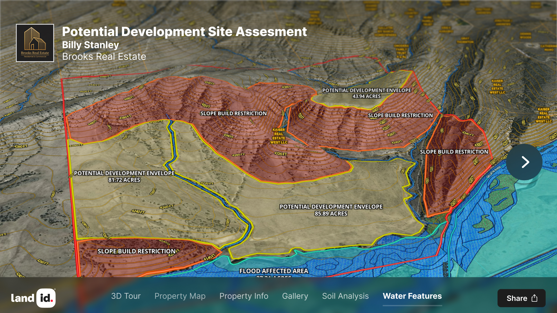
Pull the parcel ahead of your listing appointment. Confirm the legal acreage before the seller quotes you a number you'll have to walk back later. Note any flood zone exposure or subdivision restrictions you'll need to address. Show up with an annotated parcel map on your tablet instead of a printout from the MLS—it's a sharper presentation, and it's built from official data using professional real estate mapping software instead of screenshots.
Transaction Management
When a deal is in contract, parcel data helps you keep everyone aligned. Share the parcel map with the buyer's lender, insurance agent, and contractor. Confirm that the parcel in the title, survey, and MLS match. Catch boundary discrepancies or visible encroachments in aerial imagery before they become unwelcome surprises.
Client Communication
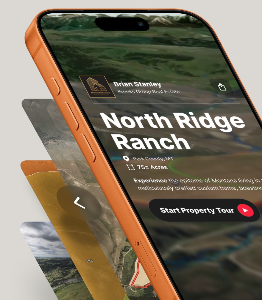
Land id lets you turn any property search into a shareable, branded map or property tour link. Add overlays, annotations, and measurements. Brand it with your logo and contact information using interactive web and mobile mapping tools. Send a single link your client can explore interactively instead of a flat PDF that tells them nothing about what's adjacent.
A Note on Data Freshness
Parcel data updates on county-set schedules—some weekly, some annually—and Land id syncs to those feeds on a recurring basis. For most research purposes, the data is current enough to work from.
For anything with material boundary or easement implications, verify digital data against the county recorder's records and involve title, surveyors, or a land-use attorney. Parcel maps are assessment tools, not legal surveys. They're the right place to start due diligence—not the place to end it.
Make Parcel Lookup Part of How You Work
Parcel lookup isn't a research shortcut—it's a professional standard. For agents who take listing prep and due diligence seriously, the APN is the most reliable starting point you have for verified boundaries, ownership on record, flood exposure, and accurate acreage.
Whether you're pre-screening a lead before making the drive, confirming lot details before a listing appointment, or keeping a transaction from unraveling at appraisal, APN lookup surfaces the facts early. Land id puts that data across all 50 states in a single search, with the overlays and shareable maps to turn research into professional client communication.
Start with the parcel. Everything else gets sharper from there.
FAQs
How do I find a parcel number?
Is parcel number lookup more reliable than searching by address?
How do I look up who owns a parcel?
What are the limits of parcel data?
Easy Parcel Data Search
Need to find a specific property? With Land id®, you can search by APN number, landowner name, address, and more. Get fast, accurate parcel info for all 50 states in one place.
Continue Reading
Prospecting, Part 2: Find Off-Market Properties
By Land id
Find off-market properties before your competition does. 8 proven strategies for real estate agents—from absentee owner lists to parcel data.
Craig Rowe
Can Refurbishing Schools Help Solve Housing Issues?
.png)
By Land id
Old public schools are becoming apartments as enrollment drops. See why school-to-apartment conversion is adaptive reuse's fastest-growing niche.


Explore Private Parcel Data & Property Boundaries
Download the Land id app and try for free.
