


Drone mapping technology is evolving faster than ever, giving the average person access to high-quality aerial photography that would have cost tens of thousands of dollars just ten years ago. With drones, mapping projects can be conducted in locations that were previously inaccessible to human beings, such as high up on the sides of mountains or skyscrapers. Drones are also being used in the field of cartography and geomatics to map our changing world as quickly and efficiently as possible—and they can do so with a higher level of accuracy than traditional surveying methods due to their ability to hover at extremely low altitudes over their surveying sites.
With almost 2 million drones registered in the US, it’s clear that drone technology is becoming mainstream, so if you’re looking to get into drone mapping as well, read on to find out how this technology has evolved and where it’s headed in the future.
The History of Drones
First, let’s clear up what exactly qualifies as a drone. A drone, also known as an unmanned aerial vehicle or UAV, uses onboard sensors to gather information about its surroundings and can be controlled remotely by human operators or computers.
The first drone employed by the military was The Aerial Target; a British-made radio-controlled aircraft that was used for target practice in 1917. Since then, drones have been used for everything from surveillance to precision bombing runs in conflicts all over the world. However, the military isn’t the only organization that utilizes drones. As technology has advanced, so too has the ability to design more lightweight drones that can operate autonomously for extended periods. This development could lead to future breakthroughs in areas such as disaster relief efforts.
When it comes to maps, how does a drone help? Unlike traditional methods like hand-drawn maps or satellite imagery, which aren’t as high-resolution or up-to-date, drones offer a method for high-resolution, real-time data collection with minimal environmental impact.
How Are Drones Used Today?
In 2006, drones became available to use for non-military ventures. Since then, businesses have quickly incorporated drones into their work to help increase efficiency while reducing costs. Businesses and civilian uses for drones have continued to grow wildly since then, and drones have found their way into many different industries like construction, real estate, agriculture, and public safety.
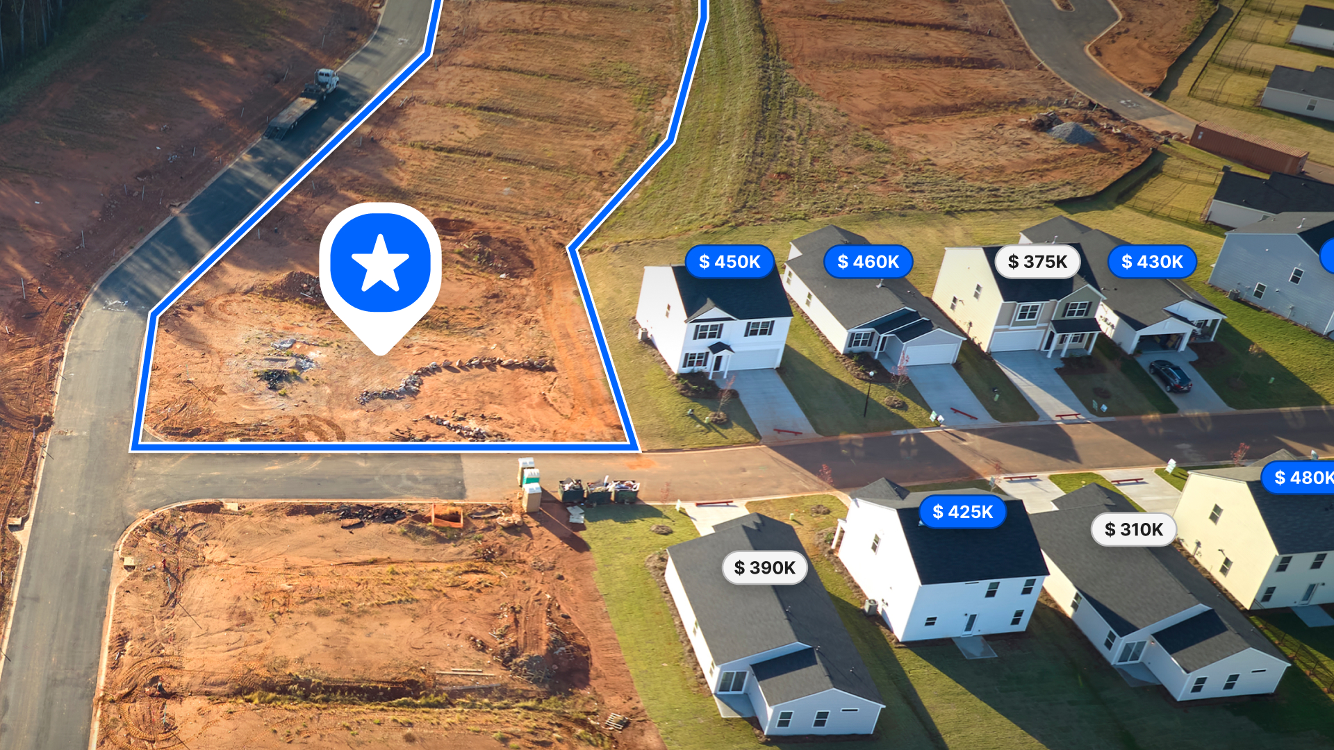
When you hear about drone mapping, you probably think about hobbyists who fly their quadcopters over a summer home in order to capture images. While that’s true, it’s not where most businesses are using drones. Today, companies and organizations use drones to complete various jobs that once required a team of humans, such as weather monitoring, surveying land for mineral deposits or vegetation changes due to climate change, wildlife tracking, crop spraying, and search-and-rescue operations.
Can Anyone Do Drone Mapping?
Yes! A few years ago, it wasn’t so easy to fly a drone. There were several reasons for that: drones are expensive, a pilot’s license is hard to get, and FAA laws made flying a drone pretty tough. Today, many more drones are on the market, and more options for getting your pilot’s license are available.
If you want to operate a drone commercially, you must first obtain an FAA-certified UAS pilot’s license, known as a Remote Pilot Certificate. In the exam, you’ll be expected to know things like applicable regulations, weather effects, emergency procedures, radio communication procedures, preflight inspection procedures, and more.
After getting your license, the next step is investing in a drone. To do that, you’ll need to know what type of projects you’ll be working on the most. Knowing the kind of project you will be doing will help you understand what kind of cameras or sensors you may need. With drone mapping, three projects stand out: area mappings, aerial photography, and digital surface models. Area mapping requires drone-mounted sensors to make measurements at specific locations. This data can then be used to create 3D models that show terrain contours and other surface details. Aerial photography captures images using a camera mounted on your drone to capture high-quality photos or videos. Digital surface models are an integrated set of digital spatial data generated from topographic survey techniques such as terrestrial laser scanning (TLS), field measurement, and GPS/GNSS positioning for areas where there is no existing coverage or ground-based point cloud databases.
What to Do With Your Data?
Once you have your license in hand and a drone ready to fly, another aspect to consider is what to do with the mapping data you collect. The data isn’t just crucial for design purposes but also for analysis, management and presentation. For some, it might be enough to simply collect information and then analyze it yourself, but if you want to actually generate maps that you can show your clients, then you’ll need to use additional software. GIS mapping software will allow you to create compelling maps and geospatial visualizations that communicate the power of this technology.
You can also utilize photogrammetry software to process the data you’ve gathered with your drone. Photogrammetry is another method of visualizing the data by creating 3D models using two-dimensional photographs and creating accurate measurements without needing expensive equipment found in traditional photogrammetry labs.
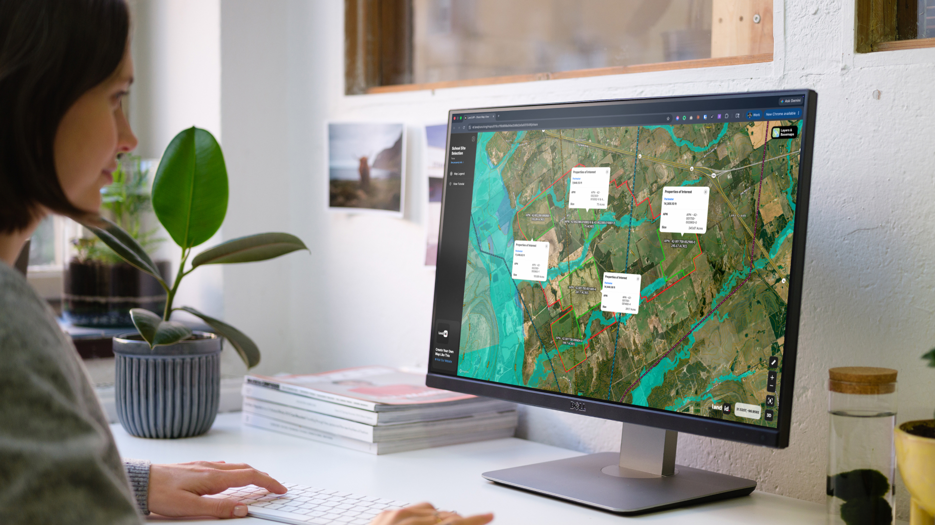
Using Land id® with Drones
Drone mapping technology has advanced by leaps and bounds over the last 100 years, leading it to become a vital tool used across all industries to gather essential data. With Land id® (formerly MapRight), we can help you use that data and imagery in your work. Land id® is a cloud-based software solution that can help you extract information from drone mapping data. You can embed panorama images, create custom databases, and use our software to create and manage interactive maps that can be published online or embedded in other web pages.
Whether you are a commercial service provider, environmental consultant, government agency, or even just an individual looking to gather important data about your neighborhood or community, Land id® can help turn your drone mapping data into actionable information. Start a 7-day free trial today!
FAQs
Continue Reading
Craig Rowe
Prospecting, Part 3: Find Land Faster
.png)
By Land id
How real estate investors and developers can use Land id to discover and analyze land-buying opportunities in less time.
How to Price Land for Sale Using Comparable Sales Data
By Land id
Learn how to price land using comparable sales. Find, analyze, and adjust vacant land comps to price listings accurately and sell with confidence.

Explore Private Parcel Data & Property Boundaries
Download the Land id app and try for free.
