


From early-morning prospecting to late-night follow-ups, real estate agents spin dozens of plates for their clients every day, making it exceptionally difficult to stay on top of what the competition is offering. Those who do keep pace understand that it’s about more than hustle and phone calls; it’s about leveraging the right tools at exactly the right moment.
This is where Land id excels.
Land id isn't just mapping software. It’s your go-to real estate marketing strategy. It's your prospecting engine, your listing differentiator, your on-site guide, your due diligence partner, and your follow-up tool—all rolled into one platform.
Let's walk through a typical day in the life of a real estate professional to see exactly how Land id creates competitive advantages.
Early Morning: Market Review & Prospecting (7:00 AM - 9:00 AM)
Your coffee's hot, your inbox is full, and you're scanning the hot sheets for new listings and recent sales in your farm areas. This is prime time to identify potential sellers, spot undervalued properties, and build your outreach list for the week.
Faster Data, Better Lead Gen
Instead of jumping between the county assessor's website, MLS, and Google Maps, you can use Land id's comprehensive parcel data to build precise farm and mailing lists in minutes. Find parcels by owner, address, APN number, acreage, assessed value, property taxes, and land use—all in one place.
Need to pull comps quickly? With our built-in comparable sales reports, quickly select nearby parcels and convert them into a client-ready report, surfacing patterns in values and sales at a glance.
Want to get really strategic? Use our rich data layers—floodplains, land use, infrastructure, wells, and more—to spot properties with hidden upside or lurking risks before you ever pick up the phone. This kind of intel helps you craft a pitch that shows you've done your homework.
Mid-Morning: Listing Appointment Preparation (9:30 AM - 11:00 AM)

You've got a listing presentation with a prospective seller this afternoon. They're interviewing three agents and you need to demonstrate local expertise, justify pricing strategy, and make a memorable impression.
Win the Listing Presentation
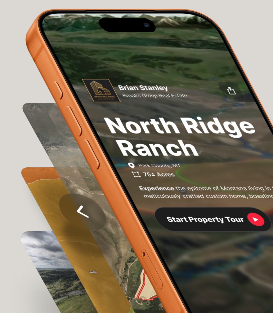
This is where Land id shines. Build branded, dynamic maps of a subject property showing parcel boundaries, acreage, topography, water features, access points, nearby amenities, and utilities for a visual story certain to cement your category expertise and marketing prowess.
Land id also offers a function to overlay tax history, assessed values, and recent comparable sales to support pricing strategy. With Land id Pro's branded maps, you can add your logo, contact information, and company details directly to the map, ensuring your brand is front and center.
Next, export the map as a high-resolution image for your CMA packet, or share a link via email or text that the potential client can explore before you even arrive. Imagine walking into that appointment with the property already mapped, analyzed, and branded with your information. That's a marketing strategy that wins listings.
Midday: Listing Appointment & Seller Consultation (11:30 AM - 1:30 PM)

You're at the property now, walking the land with the seller. They're pointing out improvements, asking about floodplains, and wondering if the back forty is buildable. This is your chance to impress—and to capture critical information.
Mobile Real Estate Intelligence
Use the Land id mobile app in the field to walk the property with the seller, showing real-time parcel lines, fence lines, trails, streams, and improvements on the map. With offline map functionality, you don't need to worry about spotty cell service—your map works anywhere.
Use it to also highlight key features as you go: prime view corridors, potential building sites, easements, water features, access points, and any seller knowledge you want to capture. These map annotations become part of the listing package and help you effectively share the property's story.
The application can also visually explain constraints and opportunities—like floodplain areas, soil types, and proximity to public lands or road access—to build trust and set realistic expectations.
Sellers love working with a real estate agent who understands the land, and Land id supports your role as the expert.
Early Afternoon: Listing Setup, Marketing, & Syndication (2:00 PM - 4:00 PM)
Back at the office, you're entering the listing into MLS, coordinating with the photographer, and setting up your marketing assets. In today's market, buyers expect more than just photos. They want context, data, and an immersive experience.
Share the Experience
Share your interactive Land id map with the photographer so they understand boundaries and what features to highlight, such as sunrise views, ski-in/ski-out access, the barn, the creek, and adjacent water features.
Embed the interactive map on your listing website or third-party sites so buyers can explore boundaries, topography, taxes, schools, and amenities all in one place. This is an especially powerful marketing strategy for land and rural properties where context matters as much as square footage.
Create 3D flyovers or zoomed-in views to use in listing presentations, email campaigns, and social media marketing. A visually rich, data-driven listing stands out in a sea of generic MLS photos and positions you as the agent who goes the extra mile.
Mid-Afternoon: Buyer Inquiries & Property Tours (4:00 PM - 6:30 PM)
Your phone's buzzing with potential buyer leads and showing requests. Some are serious, some are tire-kickers, but all of them expect you to know the property inside and out—even if it's not your listing.
Educating the Market
Send prospects a Land id map link before showings so they can orient themselves to boundaries, access, and context. This educates potential buyers and ensures your showing time is spent discussing value, not merely pointing out fence lines.
On-site, use offline maps to navigate large or remote properties, track the route you walk or ride, and show buyers exactly where they are on the parcel. With Land id's detailed mapping features, you can highlight potential building envelopes, timber stands, pasture, water rights zones, HOA boundaries, or public land adjacency in real time.
This isn't about opening the gate and letting buyers wander. It’s about telling the story of the land. Land id gives real estate agents the visual tools to do it confidently, even on properties you've never walked before.
Late Afternoon: Analysis, Negotiations, & Due Diligence (6:30 PM - 7:30 PM)

Your buyers are ready to make an offer, but they have questions. Is the property in a floodplain? Are there any wells or easements? Can they subdivide? These are the questions that can make or break a deal. You need answers fast.
Strategic Decisions to Seal the Deal
Use Land id's rich data layers—floodplains, wells, utilities, land use, soils, and public lands—to surface risks and opportunities early. This helps you protect buyers from surprises and provide confidence to move forward.
Leverage Land id’s functionality to compare subject properties to mapped comps to drive discussions about price, value drivers, and tradeoffs. When buyers see how their property stacks up against others in the area, pricing conversations become data-driven, not emotional.
Share the map with inspectors, surveyors, title companies, and attorneys so everyone is literally "on the same map" when reviewing boundaries, easements, improvements, and restrictions. This kind of coordination saves time, reduces miscommunication, and keeps deals moving.
Evening: Follow-Up, Reporting, & Client Experience (8:00 PM - 9:00 PM)

The day's winding down, but your work isn't done. You're sending recaps, nurturing leads, and maintaining your reputation as the agent who delivers.
Nurture Leads for Life
Email branded map links as a follow-up to showings and listing presentations. It's a high-value takeaway that keeps you top of mind and reinforces your professionalism.
Maintain a library of saved maps for your pipeline: active listings, upcoming listings, buyer search areas, and farm areas. With Land id, your maps become valuable marketing materials that are always accessible, always up to date, and always ready to share.
Use visual property stories—before/after improvements, development concepts, subdivision scenarios—to keep clients engaged over long decision cycles. Real estate isn't always fast, but staying visible and valuable is how you win the long game.
The Bottom Line: Land id Works Round the Clock
Life as a real estate agent is demanding. Your day starts early, ends late, and is packed with competing priorities. You need marketing strategies that don't slow you down. You need tools that help you prospect smarter, present better, and close faster.
Land id is the one real estate marketing tool that not only helps you create beautiful property maps (see for yourself in our map gallery), but also integrates seamlessly into every stage of an agent’s daily workflow.
Whether you're building farm lists at dawn or sending follow-up maps at midnight, Land id is there, helping you deliver the kind of experience that wins listings, earns referrals, and sets you apart from the competition.
Ready to See How Land id Fits Into Your Day?
Start your free 7-day trial and discover how the best agents in the business use Land id to work smarter, not harder.
FAQs
Can I use Land id on my phone while showing properties?
How do I add my branding to a Land id map?
Can I share maps with people who don't have a Land id subscription?
What kind of data layers are available in Land id?
How do I create mailing lists in Land id for prospecting?
List & Sell Property With Confidence
Measure structures, frontage, and usable land so your listings are accurate, defensible, and trustworthy.
Continue Reading
Alyssa Toohey
Off the Map & In Person: The Land id Team Gets Together

By Land id
The Land id team came together in Montana for collaboration, connection, Big Sky views, PBR, Yellowstone, and plenty of memorable moments.

How Land id Works for Residential Agents
By Land id
Learn how Land id helps residential real estate agents visualize location, uncover property context, and market listings with greater impact.


Explore Private Parcel Data & Property Boundaries
Download the Land id app and try for free.
