


Imagine having a superpower that allows you to see patterns and relationships hidden within a land map. That's exactly what GIS does. It's a supercharged map-making tool that unlocks a deeper understanding of our world.
In this blog post, you'll discover the fundamentals of GIS mapping, how it works, and its diverse applications across various industries. We'll also delve into the history of GIS, its core components, and the significant benefits it offers.
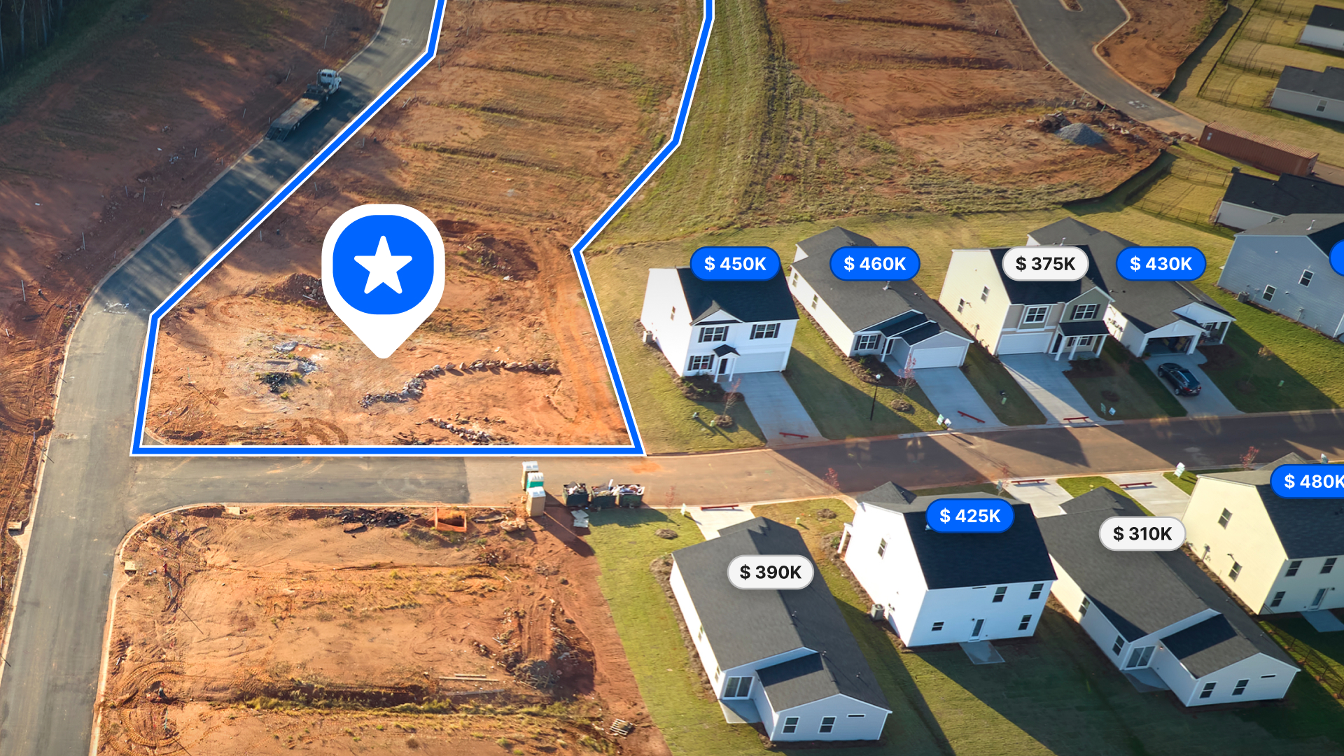
Plus, we will explore how Land id® leverages GIS technology to provide powerful mapping tools and overlays.
Main Takeaways From This Article:
- GIS Mapping is a powerful tool that integrates geographical data with customized mapping technologies.
- This technology has transformed various sectors by providing enhanced decision-making capabilities and detailed spatial analysis.
- It captures, stores, checks, and displays data related to positions on Earth’s surface and is used for problem identification, trend analysis, resource allocation, risk assessment, and operational optimization.
- The core components of GIS include hardware, software, and spatial data, which work together to manage and analyze geographical information.
- Land id® offers advanced GIS mapping services, allowing users to experience powerful mapping tools and overlays.
What Is a Geographic Information System (GIS)?
A Geographic Information System (GIS) is a technology used to collect, manage, analyze, and visualize spatial and geographic data. What sets GIS apart is its ability to link descriptive information to a map, allowing for the exploration of patterns, relationships, and trends across various locations that might not be readily visible.
What Are Geographic Information Systems Used For?

Geographic Information Systems (GIS) are versatile tools that help visualize, analyze, and interpret spatial data to understand relationships, patterns, and trends. Here are some key applications of GIS:
Problem Identification
GIS provides a clear picture of spatial data, making it easier to identify and understand problems in various contexts. Whether it's assessing environmental impacts, planning urban development, or managing disaster responses, GIS helps pinpoint issues accurately, enabling better strategizing and solution development.
Trend Analysis
By combining different datasets and utilizing spatial analysis, GIS is invaluable for identifying trends over time and across locations. This capability allows businesses, governments, and researchers to detect patterns in market changes, environmental shifts, and social behaviors, facilitating data-driven decision-making and strategic planning.
Resource Allocation
GIS optimizes resource use by identifying the best locations for infrastructure, emergency response planning, and environmental conservation. By leveraging precise geographic data, GIS ensures that resources are allocated efficiently, minimizing waste and enhancing overall decision-making processes.
Risk Assessment
Before undertaking construction or development projects, understanding potential risks is crucial. GIS can overlay hazard data, such as flood plains and earthquake zones, onto property maps to assess risks. This information is essential for choosing safer locations and implementing necessary precautions to mitigate potential hazards.
The History of GIS
The 1960s-1970s
Understanding GIS begins with its history, starting in the 1960s. Roger Tomlinson, a Canadian government employee and the "father of GIS," developed the Canadian Geographic System (CGIS). Unlike earlier mapping programs, CGIS introduced a layered approach to map handling, setting the foundation for contemporary GIS.
Shortly after, Tomlinson played a pivotal role in creating the Canadian Land Inventory (CLI). This project assessed land capability for various uses like agriculture and forestry, utilizing data on soil, drainage, and climate. The CLI helped Canadians better manage their natural resources and marked the inception of GIS. In 1968, Tomlinson also officially coined the term "geographic information systems," cementing his legacy in the field.
The Late 1970s-1980s
As the late 1970s arrived, advancements in computer technology—specifically in memory and graphics capabilities—enabled the commercialization of GIS software.
The 1990s-2010
Between the 1990s and the 2000s, the affordability and capability of computers improved dramatically. Alongside the widespread availability of software and data, the launch of new satellites, and the rise of remote sensing, these developments propelled GIS into mainstream use. Today, GIS technology is utilized by educational institutions, governments, individuals, and businesses worldwide.
Core Components of GIS

Understanding the core components of GIS is essential for harnessing its full potential. These components work together to collect, manage, analyze, and visualize geographic data.
GIS Software
In the realm of GIS, software is the critical component where the transformative processes occur. It enables the storage, retrieval, management, display, and analysis of geographic and spatial data.
Spatial Data
Data is arguably the most crucial element of GIS since it forms the foundation for all visualizations and analyses. The strength of GIS lies in its ability to merge spatial data, which pinpoints the exact or relative position of a geographical feature, with attribute data. This attribute data provides additional details about the feature, such as a building's name, regional demographics, construction year of a structure, or the soil's mineral composition.
How Does GIS Work?

GIS has the ability to transform raw data into actionable insights. Here's a simplified look at the GIS workflow:
Data Collection and Input
This is the foundation of any GIS project. GIS data are of two types: vector data and raster data. It can gather information from a variety of sources, such as:
- Satellites: Images captured from space can reveal details about land cover, deforestation, and even weather patterns.
- GPS (Global Positioning System): This technology helps pinpoint the exact location of features on Earth's surface.
- Aerial Photography: High-resolution aerial photos provide detailed imagery of specific areas.
- Surveys and Fieldwork: On-the-ground data collection through surveys and measurements can capture valuable information.
- Existing Databases: Government agencies, utility companies, and other organizations often have relevant geospatial data available.
Data Management and Storage
Once the data has been collected, it needs to be organized and stored efficiently. GIS software provides tools to:
- Clean and Standardize Data: Ensure data consistency and accuracy for seamless integration within the system.
- Organize Data Into Layers: Imagine stacking transparencies. Each layer in GIS represents a specific type of data, such as roads, buildings, or soil composition. By combining these data layers, you create a comprehensive picture.
- Attribute Data Management: Link descriptive information to specific locations. For example, you might connect data on building heights to building footprints on a map.
Data Visualization and Mapping
This is where the power of GIS truly shines. The software transforms raw data into visually compelling GIS maps and graphics. Here are some key features:
- Basemap Selection: Choose a background map that provides context, like political boundaries, topography, or satellite imagery.
- Theming and Symbology: Apply colors, patterns, and symbols to represent different types of data on the map.
- Cartographic Techniques: Utilize tools like legend creation, scale bars, and north arrows to ensure clear and professional map design.
Spatial Analysis Techniques
GIS goes beyond just creating maps – it allows you to uncover hidden patterns and trends within your data:
- Overlay Analysis: Layer multiple data sets on top of each other to identify spatial relationships and interactions.
- Proximity Analysis: Find features that are close together, useful for tasks like locating potential customers or identifying areas at risk for pollution.
Data Sharing and Reporting
The insights gained from GIS analysis are valuable for communication and collaboration. Here's how GIS facilitates sharing:
- Interactive Maps: Create dynamic maps that allow users to explore data and discover insights on their own.
- Reporting Building: Generate reports that combine maps, charts, and text to effectively communicate findings.
- Data Export: Share data in various formats for use in other software or platforms.
Applications of GIS Across Industries
GIS is a powerful tool used in a wide range of fields. Let's explore a few examples:
- Environment: GIS has revolutionized environmental conservation, offering tools to monitor climate change, assess environmental impacts, and manage disasters such as pollution, forest fires, and oil spills.
- Forestry: In forestry, geospatial technology is critical for combating deforestation and managing resource inventories.
- Agriculture: GIS technology has transformed agriculture, enabling precision farming, soil mapping, and the efficient planning of crop and livestock rotations.
- Real Estate: The impact of GIS in real estate is profound. Realtors utilize it for tasks such as conducting sales comparisons, locating properties, market research, zoning analysis, and property promotion.
- Business: Businesses leverage GIS for site selection, market analysis, customer segmentation, and product placement strategies, benefiting from its comprehensive data capabilities.
- Engineering: GIS is also integral to civil engineering, where it is used to visualize project data, conduct impact assessments, evaluate economic viability, and comply with zoning laws.
- Public Safety: In public safety, GIS plays a vital role in tracking disease spread, crime mapping, disaster response, and monitoring public health.
Benefits of GIS Mapping

GIS mapping isn't just about creating beautiful maps; it's a powerful tool that revolutionizes the way we approach challenges and make decisions. Here's how GIS empowers its users:
Enhanced Decision-Making
With GIS, you can transform data into actionable insights that guide informed decision-making. By overlaying multiple data sets on a map, you can identify trends, assess risks, and optimize resource allocation. This empowers you to make strategic choices with greater confidence. Land id® offers extensive data overlays and parcel information, providing a comprehensive view for better decision-making.
Improved Efficiency and Cost Savings
Time is money, and GIS helps you save both. By streamlining workflows and optimizing processes, GIS can significantly improve efficiency. Imagine a utility company using GIS to plan service routes. They can reduce travel times, optimize technician schedules, and minimize fuel costs by factoring in traffic patterns and real-time data. These efficiencies translate to significant cost savings over time. Land id®’s offline map creation and driving directions help ensure smooth field operations, enhancing efficiency and reducing costs.
Accurate Data Integration
GIS acts as a central hub, seamlessly integrating data from various sources. Imagine environmental data collected from field studies, satellite imagery showing forest cover, and weather patterns tracked by monitoring stations. GIS can integrate all this information, providing a holistic view of the environment. Land id® integrates private and public parcel data, as well as environmental data, offering a unified platform for comprehensive land analysis.
Dynamic Data Visualization
Static charts and graphs can be limiting. GIS brings data to life through visually compelling and interactive maps. Imagine complex demographic data transformed into a color-coded map that highlights areas with high population density. This allows users to easily grasp patterns and trends that might be missed in traditional data presentations. Land id®’s dynamic overlays and interactive map creation features provide users with powerful visualization tools to easily interpret complex data in no time.
Scalability and Flexibility
GIS is a technology that grows with your needs. Whether you're managing a small dataset for a local project or working with vast quantities of information across a large region, GIS can handle it. The software is adaptable to various project sizes and complexity levels. Land id®’s scalable solutions cater to various industries and project sizes, ensuring flexibility and adaptability for all users.
Discover the Power of GIS Mapping With Land id®
Unlock the full potential of geographic information systems with Land id®. Our platform empowers diverse industries—from real estate and agriculture to government and environmental consulting—with precise, comprehensive, and actionable spatial data.
By enhancing decision-making, improving resource management, and fostering collaboration, Land id® provides the tools you need to tackle complex challenges and achieve your goals efficiently.
With just a few clicks, you can access detailed soil reports, customize databases, manage various GIS layers, and much more.
Now that you're familiar with the basics of GIS, why not experience this technology firsthand? Sign up for a free 7-day trial with Land id® today!
FAQs
Continue Reading
How to Price Land for Sale Using Comparable Sales Data
By Land id
Learn how to price land using comparable sales. Find, analyze, and adjust vacant land comps to price listings accurately and sell with confidence.
Craig Rowe
Can Refurbishing Schools Help Solve Housing Issues?
.png)
By Land id
Old public schools are becoming apartments as enrollment drops. See why school-to-apartment conversion is adaptive reuse's fastest-growing niche.


Explore Private Parcel Data & Property Boundaries
Download the Land id app and try for free.
