

Have you ever stood in your yard wondering exactly where your property ends—or why the neighbor’s fence seems suspiciously close? That’s where plat maps save the day.
Plat maps are official, legal documents that show how land is divided and who owns what. They lay out parcels, lots, roads, easements, and even natural features, giving everyone a clear picture of the land.
In this guide, you’ll learn what plat maps are, how to read them without getting overwhelmed, and why they matter more than most people realize. You’ll also learn how to use Land id to view and interpret plat maps, and even make your own plat-style map.
Main Takeaways
- A plat map is a legal map that shows how land is divided into lots, streets, and easements. It serves as the reference for public records about who owns each lot.
- Plat maps benefit homeowners, developers, and governments by clearly defining boundaries, supporting informed planning efforts, and preventing disputes.
- Land id’s Parcel layer is derived from county plat maps, making it fast and easy to analyze property details.
- While you can’t make a legal plat map with Land id, you can easily import an existing plat and make plat-style maps that reveal important property data.
What Is a Plat Map?
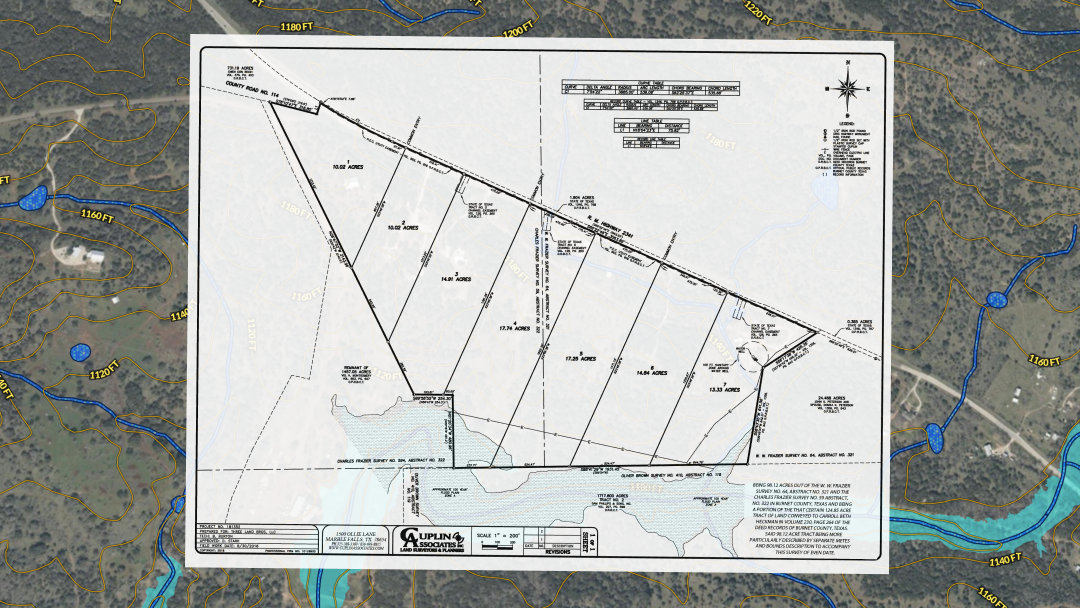
A plat map is essentially a scaled drawing that breaks down a piece of land into its components. Think of it as a property’s blueprint showing elements like:
- Lot dimensions
- Property lines
- Streets and access points
- Easements
- Flood zones
Plat maps help with everything from buying or selling a home to settling boundary disputes.
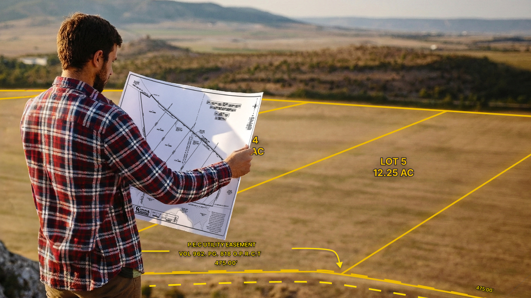
How To Read a Plat Map
.png)
At first glance, plat maps can look like a maze of lines and numbers. But once you know what you’re looking at, the structure becomes surprisingly intuitive.
Here’s what to pay attention to:
Property Boundaries
These are the solid lines outlining a parcel—your land’s “fence line” on paper.
Lot Dimensions
Measurements along those boundaries (in feet or meters) tell you the size and shape of the property.
Landmarks
Roads, rivers, buildings, and other features are marked so you can orient yourself. You’ll also see additional notations and symbols, including:
- North arrow—Shows orientation
- Scale—Tells you how map distance compares to real life
- Lot numbers—Identify individual parcels
- Easements—Often shown with dashed lines
- Contour lines—Represent elevation changes
Tips for Interpretation
If you’re feeling lost, focus on the basics:
- Check the legend—it’s the key to understanding each symbol.
- Find boundary lines to grasp the property's outline.
- Review lot dimensions to understand size.
- Reference landmarks to get your bearings.
Once you get the hang of these elements, reading plat maps becomes much more approachable.
Types of Plat Maps
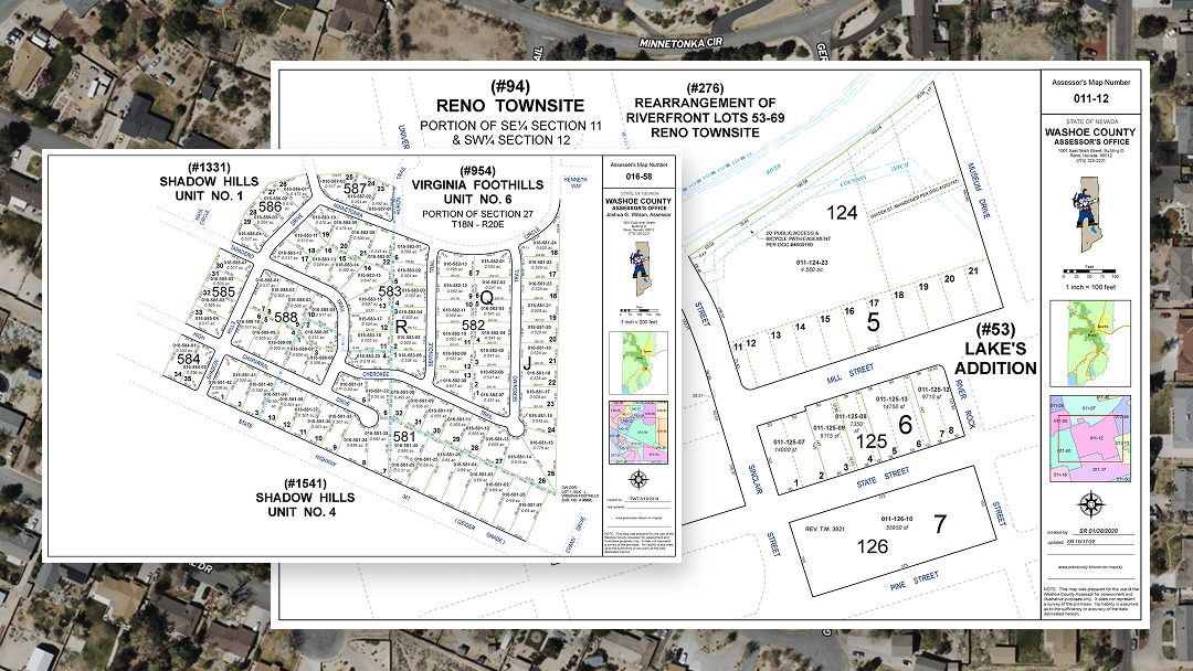
Plat maps aren’t one-size-fits-all. Depending on the needs and priorities of the community, plat maps can cover different jurisdictional scopes (county, city, town, subdivision) and can contain much more information than simple boundary lines. These include utility/conservation/transportation easements, topographic elevation and terrain data, floodplain boundaries, and more.
Each type serves a specific role in property planning and decision-making.
Benefits of Plat Maps
For Homeowners
Plat maps can reveal insights that aren’t obvious from just standing on the property—insights that could drastically influence property decisions, such as:
- Sun orientation: By checking directionality, you can determine whether a lot is ideal for solar panels, which rooms will get morning light, or where a pool might make sense.
- Floodplain risks: If the lot lies in a flood zone, a plat quickly tells you—and that can influence insurance needs.
- Ownership clarity: Because plat maps hold legal authority, they help resolve disputes and confirm exactly what land is yours.
For Governments
Local governments rely on plats to keep order and maintain public safety. They help officials:
- Confirm compliance with zoning rules.
- Ensure that utilities and rights-of-way are properly accounted for.
- Guide city planning and development decisions.
When Should You Get a Plat?
Before paying for a new plat, check whether one already exists. Here’s a quick rule of thumb:
- Lot-and-block descriptions in a deed usually mean the land is already part of a recorded subdivision plat, so you may not need a new plat unless you are changing lot lines or creating new lots.
- Metes and bounds (or similar) descriptions are more common for unplatted or irregular tracts. Local subdivision rules may require a new plat if you want to divide, reconfigure, or develop that land.
You’ll typically need a new plat for situations like:
- Developing or subdividing land.
- Merging parcels.
- Turning private land into public use.
- Adding an easement.
- Correcting errors in an existing plat.
Local regulations may require additional steps, so it’s better to play it safe and check county requirements.
How To Obtain a Plat Map
Finding an existing plat map is easier than most people expect. You can:
- Visit the county assessor’s office. Many counties keep public plat records.
- Look online. Some counties publish digital plat maps on their websites.
- Reach out to a title company. For a fee, they can provide historical plat records.
If You Need a New Plat Map
If no plat exists or the existing one is outdated, you’ll need to hire a licensed surveyor. The process usually goes like this:
- Surveyor examines the property and collects field data.
- New plat is created, incorporating accurate measurements and legal details.
- Local authorities review and approve the new plat.
A licensed surveyor will ensure the map holds legal weight and prevents future disputes.
Using Land id® for Making Plat-Style Maps
Plat maps are official, legal documents made by licensed surveyors, but Land id can create plat-style maps by entering deed calls. The software automatically draws the corresponding lines and curves—no manual drafting required. If you already have a survey image, our Georeference tool lets you overlay it onto the map for precise alignment.
Beyond drawing boundaries, Land id offers:
- Street-view layers for real-world context.
- GIS layers such as floodplains, zoning, public lands, and administrative boundaries.
- Annotation tools for marking easements, rights-of-way, trails, buffers, and more.
Land id works seamlessly with existing plat maps and surveys to help you better understand the land's risks and potential.
Example Map Using Land id + an Imported Original Plat Map
This interactive Land id map combines an original plat document with real-time GIS layers. Experience the property with full context by zooming in on specific easements and checking the floodplain layers against the surveyor’s original drawings.
Learn how to do this yourself by importing surveys, plats, and site plans with Land id's Georeference tool.
Simplify Property Analysis With Land id
Plat maps are powerful tools, but historically, they’ve been complicated to work with. Land id changes that. Whether you're a surveyor working with plats, a homeowner trying to understand your property, or a real estate professional who needs context-rich, shareable maps, Land id makes it easy make sense of the land so you can plan confidently.
Start your 7-day free trial to try it for yourself.
FAQs
Can I use Land id to make a plat map?
What’s included in a plat?
What’s the difference between a plat and a replat?
What’s the difference between a plot and a plat?
What’s the difference between a survey and a plat?
What’s the difference between platted and unplatted land?
Continue Reading
Prospecting, Part 2: Find Off-Market Properties
By Land id
Find off-market properties before your competition does. 8 proven strategies for real estate agents—from absentee owner lists to parcel data.
Craig Rowe
Can Refurbishing Schools Help Solve Housing Issues?
.png)
By Land id
Old public schools are becoming apartments as enrollment drops. See why school-to-apartment conversion is adaptive reuse's fastest-growing niche.


Explore Private Parcel Data & Property Boundaries
Download the Land id app and try for free.
