

Ever wondered how urban planners figure out the best spots for new parks or how farmers decide where to plant their crops for the best yield? The answer lies in a powerful tool called 'Geographic Information System' or GIS.
This blog post discusses how GIS empowers professionals with location-based insights, ultimately enhancing decision-making and strategic planning. We'll also introduce Land id® – a platform that leverages GIS technology to elevate your property and land analysis capabilities.
Main Takeaways From This Article:
- GIS technology plays a crucial role in decision-making and strategic planning across fields like environmental management, public safety, urban planning, and even mobile banking to capture locations where existing mobile transactions occur.
- Understanding GIS applications can greatly benefit professionals by improving their insight and strategic capabilities in their respective sectors.
- Key components of GIS include software, hardware, spatial data, people, and methods, each contributing to the effective use of geographic information.
- Diverse industries such as real estate, agriculture, government agencies, and environmental conservation utilize GIS for enhanced operational efficiency.
- Land id® is a powerful tool leveraging GIS for property and land analysis, providing users with advanced mapping features and data layers.
Introduction to GIS Applications
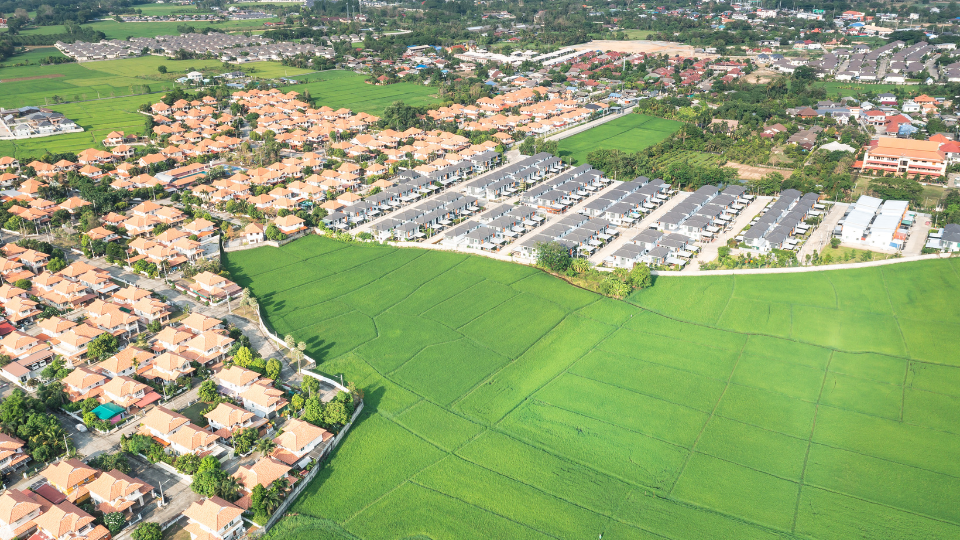
Geographic Information Systems (GIS) are powerful tools that allow us to visualize, analyze, and interpret data to understand spatial relationships and patterns. Essentially, GIS technology combines layers of information about a place to give you a better understanding of that location. Whether it's mapping out property lines, analyzing soil types, or planning the best route for a new road, GIS helps us make sense of complex data by providing a visual context.
The world of GIS is constantly evolving. What began with desktop software now extends to mobile apps, cloud-based platforms, and even drone-captured imagery. This growing accessibility means GIS applications are finding their way into an ever-expanding list of industries.
Key Components of GIS
Let's break down the core components that make GIS such a powerful tool:
1. GIS Software
GIS software is the core of any GIS system, providing the tools needed to analyze and visualize spatial data. This software enables users to manipulate data, generate detailed maps, and derive valuable insights from geographic information.
2. Hardware
While powerful software is essential, robust hardware is needed to handle complex datasets and visualizations. This can include high-performance computers and specialized servers. Both hardware and software systems must work seamlessly to ensure smooth, efficient, and precise processing of geospatial information.
3. Spatial Data
Spatial data is the backbone of GIS, consisting of information about the physical location and characteristics of geographic features. This data helps users understand land characteristics, ownership, and usage, enabling informed decision-making. Spatial data can include maps, satellite images, and detailed property information.
4. People
The people component refers to the users and professionals who operate and benefit from GIS technology. These users include real estate professionals, appraisers, developers, agricultural experts, government agencies, environmental consultants, and surveyors. They leverage GIS to access vital land and property data, create custom maps, and conduct detailed analyses.
5. Methods
Methods encompass the techniques and processes used to collect, analyze, and interpret spatial data. Advanced GIS methodologies ensure accurate and reliable data. These methods include data collection techniques, such as remote sensing and field surveys, as well as analytical processes like spatial analysis and geostatistics.
Diverse Industries Utilizing GIS
GIS is a transformative tool that empowers professionals across industries to make informed decisions and optimize their operations. Let's explore how some specific sectors leverage GIS for their success:
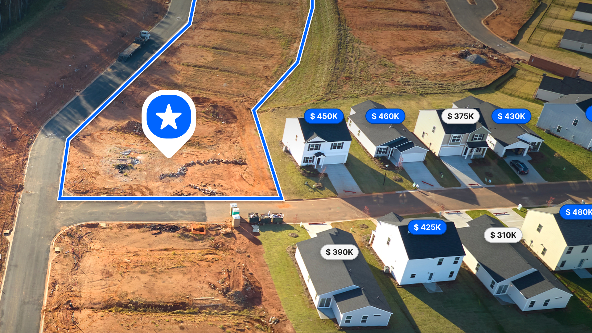
Real Estate Professionals
The real estate industry thrives on location, location, location. GIS provides a powerful lens through which to understand the geographic distribution of properties and market trends. It aids in:
- Property Visualization: GIS allows realtors to create interactive maps showcasing a property's surroundings. Imagine potential buyers viewing a property alongside nearby schools, parks, and public transportation options, all on a user-friendly map. This enriched visualization creates a more compelling experience and helps buyers make informed decisions.
- Market Analysis: Market research is key for real estate professionals. GIS allows them to analyze trends like property values, and development projects across specific geographical areas to identify lucrative investment opportunities and make data-driven decisions.
- Property Management: For property managers looking to expand or develop new facilities, GIS provides tools to analyze zoning information, property boundaries, and surrounding land use. This helps in making informed decisions about property development and ensuring compliance with local regulations.
Applications of GIS in Real Estate
A real estate company can use Land id® to find the optimal location for a new retail store in a metropolitan area. By leveraging our comprehensive land and property data, they can analyze property boundaries, ownership details, and nearby property details required to pinpoint areas with high potential.
Another example is a city planning department that employs GIS to identify underutilized properties suitable for redevelopment. By overlaying zoning data, and property conditions, they prioritize areas for investment and development. This facilitates revitalization efforts, improves urban landscapes, and boosts local economies.
Appraisers and Valuers
Accurate property valuation requires a comprehensive understanding of the property itself and its surrounding environment. GIS empowers appraisers to make informed judgments based on:
- Precise Property Evaluation: GIS allows appraisers to consider a range of factors that influence property value. They overlay data on flood risk zones, proximity to transportation hubs, historical sales data within the vicinity, and even crime statistics for more precise valuations and to minimize risk for lenders and investors.
- Condition Assessments: While a physical inspection is vital, GIS can provide valuable insights for appraisers. Layering data on historical environmental incidents like oil spills or nearby construction projects can help assess potential risks associated with a property.
Applications of GIS for Appraisers and Valuers
An appraiser evaluating a coastal property can use GIS to analyze historical flood data and sea-level rise predictions, providing a more comprehensive risk assessment.
Similarly, when valuing a commercial property near a major infrastructure project, GIS can help determine the future impact on property value by examining planned urban development and traffic patterns.
Builders and Developers

A development project's success hinges on picking the right location and strategically planning every detail. GIS empowers builders and developers throughout this process with:
- Site Selection: GIS allows developers to analyze factors like land availability, zoning regulations, and infrastructure access. By visualizing these factors on a map, developers can identify sites with the highest development potential, minimizing risk and maximizing ROI.
- Project Planning: GIS helps developers visualize their project within the geographical context and analyze factors like traffic patterns, noise levels from nearby highways, and sun exposure based on surrounding buildings. This helps them optimize the development's design and layout.
- Development Feasibility Studies: GIS allows developers to assess the viability of a development project with data overlaid on construction costs, projected market trends, and potential environmental impacts based on the chosen location.
Applications of GIS for Builders and Developers
Using GIS, a developer can identify and evaluate potential sites for new projects. By accessing comprehensive parcel data, property boundaries, and map layers, they can compare different locations based on factors such as accessibility, land characteristics, and surrounding infrastructure. This ensures that they choose the most suitable site for their development needs.
Agricultural Professionals

For farmers, maximizing yield while minimizing environmental impact is a constant pursuit. GIS empowers them with a powerful tool for:
- Crop Planning: Planting the right crop in the right place is crucial for agricultural success. GIS allows farmers to analyze factors like soil composition, historical weather patterns, and elevation data and identify optimal planting zones for different crops, maximizing yield potential.
- Irrigation Resource Management: Water is a precious resource, especially in agriculture. GIS helps farmers optimize irrigation practices by layering data on soil moisture levels, crop water requirements, and weather forecasts to create precise irrigation plans that minimize water waste.
- Land Use Optimization: Not all land is created equal. GIS helps farmers assess their land for different crop suitability. By analyzing factors like slope, drainage, soil type, and sun exposure, they identify areas best suited for high-value crops or prioritize land restoration projects in less suitable areas.
Applications of GIS for Agricultural Professionals
Farmers use GIS to analyze soil health, crop conditions, and irrigation needs. By overlaying soil reports and other relevant map layers, they can determine the best areas for planting, optimize fertilizer use, and plan efficient irrigation schedules. This leads to improved crop yields and reduced environmental impact.
Government Agencies
From managing land records to planning infrastructure projects, GIS empowers government agencies to serve citizens more effectively. It allows them to:
- Manage Land Records: Efficient land record management is crucial for various government functions. GIS allows agencies to create digital land parcel maps, track ownership changes, and streamline property tax collection. This ensures transparency and reduces the risk of land disputes.
- Plan and Develop Strategically: GIS allows government agencies to analyze factors like population density, land use patterns, and environmental constraints to develop informed zoning regulations and plan infrastructure projects strategically for sustainable growth.
- Infrastructure Management: Maintaining roads, bridges, and other infrastructure assets is essential for the government. GIS allows agencies to track the location and condition of these assets, plan maintenance schedules, and manage resources efficiently.
Applications of GIS in Government Agencies
GIS enables emergency response teams to visualize and analyze real-time data for disaster management and response. By mapping out emergency routes, shelters, and affected areas, agencies can coordinate relief efforts more effectively and minimize response times.
Government agencies use GIS for water resource management. They monitor and manage water bodies, predict flooding risks, and control water quality. GIS data helps in planning water conservation efforts, tracking water usage, and ensuring compliance with environmental regulations.
Environmental Consultants and Conservationists

Protecting the environment requires a deep understanding of ecosystems and their interactions. GIS equips environmentalists with the tools for:
- Environmental Impact Assessments: Environmental impact assessments are crucial before approving development projects. GIS lets consultants analyze factors like habitat suitability for endangered species, potential water pollution risks, and impacts on natural resources.
- Conservation Planning: Protecting endangered species and sensitive ecosystems is a core responsibility for conservationists. GIS allows them to map critical habitat areas, track wildlife migration patterns, and identify areas vulnerable to climate change.
- Managing Sustainable Developments: Balancing development needs with environmental protection is a delicate task. With GIS, consultants can work with developers to identify areas suitable for sustainable construction practices. This can include analyzing factors like solar energy potential, proximity to public transportation, and minimizing waste generation during construction.
Applications of GIS for Environmental Consultants and Conservationists
Environmental consultants use GIS to monitor air quality in urban areas. By mapping pollution sources and concentration levels, they can identify hotspots and recommend measures to improve air quality, ensuring compliance with health standards.
Conservationists leverage GIS to manage invasive species in protected areas. By mapping the spread and density of invasive plants or animals, they can prioritize areas for removal efforts, thus protecting native biodiversity and maintaining ecological balance.
Surveyors

Surveyors prioritize precision and efficiency. GIS provides a powerful toolkit to ensure precise measurements and streamline the surveying process with:
- Accurate Land Measurement: Traditional land surveying relies on physical measurements. GIS lets surveyors integrate these measurements with digital maps and satellite imagery and enhance accuracy, allowing for real-time data visualization and reducing the risk of errors.
- Boundary Determination: Disputes over property boundaries can be complex. GIS allows surveyors to overlay historical land records, aerial photographs, and digital elevation models onto a map. This helps them accurately determine property boundaries and resolve disputes effectively.
- Site Planning: Before construction begins, it's important to get detailed site plans in place. GIS allows surveyors to create digital site maps with precise topographical features and property boundaries to empower engineers and architects to plan construction projects more effectively.
Applications of GIS for Surveyors
Surveyors utilize GIS to generate detailed topographic maps. These maps can highlight elevation changes, land contours, vegetation, and obstacles, aiding in accurate terrain analysis for various projects such as road construction, mining, and landscape architecture.
GIS is instrumental in mapping the locations of underground utilities such as water pipes, gas lines, and electrical grids. Surveyors can use these maps to avoid potential hazards during excavation, ensuring safety and compliance with regulations.
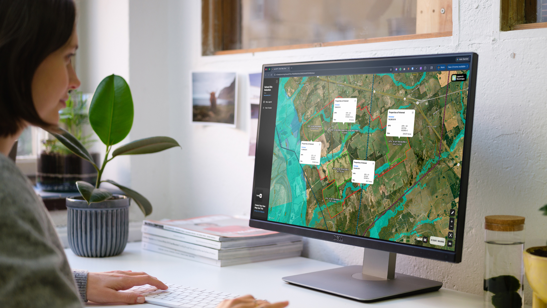
Leverage Land id® for Enhanced GIS Data Analysis
We've explored how GIS empowers various industries. But how can you leverage this powerful technology for your own needs? This is where Land id® comes in.
Land id® is a user-friendly platform that provides you with access to a wealth of GIS data layers specifically relevant to property and land analysis.
Here's how Land id® enhances GIS data analysis:
- High-Resolution Maps: Visualize your property in detail with up-to-date aerial imagery and detailed topographic maps.
- Rich Data Layers: Land id® offers a comprehensive suite of data layers, including property boundaries, floodplains, well locations, land use, and zoning regulations.
- Offline Functionality: Land id® lets you download maps for offline use. This is especially helpful for professionals needing access to data in remote locations with limited internet connectivity.
By leveraging Land id®, you can make informed investment decisions, optimize land management, and streamline project planning by harnessing the power of GIS and unlocking a new level of understanding of your property and land.
Want to see Land id® in action?
FAQs
Continue Reading
Craig Rowe
Prospecting, Part 3: Find Land Faster
.png)
By Land id
How real estate investors and developers can use Land id to discover and analyze land-buying opportunities in less time.
How to Price Land for Sale Using Comparable Sales Data
By Land id
Learn how to price land using comparable sales. Find, analyze, and adjust vacant land comps to price listings accurately and sell with confidence.

Explore Private Parcel Data & Property Boundaries
Download the Land id app and try for free.
