


You might have wondered exactly where your property line ends and your neighbor's begins. Or maybe you're planning a renovation and need to ensure everything stays within legal boundaries. Peace of mind is priceless, especially when it comes to your most significant investment – your property.
A property survey is crucial in safeguarding your real estate interests, preventing headaches, and ensuring smooth property transactions. But what exactly is a property survey, and why is it so important? Let's find out.
Main Takeaways From This Article:
- Property surveys are detailed maps that define a property's boundaries, dimensions, and features. They are crucial for clarifying property lines and resolving disputes.
- Having an updated property survey ensures compliance with zoning laws and aids in planning new constructions or renovations.
- Different types of property surveys, such as boundary surveys, mortgage surveys, and floodplain surveys, cater to specific needs.
- Obtaining a property survey involves hiring a licensed surveyor who uses sophisticated tools to deliver accurate data.
- Land id® offers comprehensive mapping tools and reliable boundary data, making the process of obtaining a property survey more accessible and efficient.
What Is a Property Survey?
A property survey is a detailed drawing or map that outlines a piece of land's boundaries, dimensions, and physical features. Understanding the specifics of your property is crucial whether you're a prospective homebuyer, a seasoned real estate investor, or a homeowner planning renovations.
Importance of Property Surveys
A property survey goes beyond a simple map. It serves as a vital piece of documentation for numerous reasons:
- Clarifying Property Lines: Property lines can get blurry over time, especially with aging fences or unclear deeds. A survey helps pinpoint the exact boundaries, preventing potential disputes with neighbors and ensuring you're utilizing your land to its full potential.
- Resolving Disputes: Boundary disagreements can escalate quickly. A current property survey acts as a neutral and official record, preventing expensive legal battles and fostering amicable relationships with your neighbors.
- Compliance With Zoning Laws: Are you thinking of building a new deck or adding an extension? Zoning regulations dictate what and where you can construct on your property. A property survey ensures your planned project adheres to these guidelines, avoiding costly delays or fines.
- Protecting Your Investment: Owning land is a significant investment, and a property survey safeguards that investment. It verifies the size and location of your property, ensuring you're getting what you paid for and protecting your rights.
Types of Property Surveys

The world of property surveys offers a variety of options to cater to your specific needs. Let's explore the different types of surveys available and understand which one best suits your situation:
Boundary Survey
This is the bread and butter of property surveys. It focuses on meticulously measuring and establishing the exact legal boundaries of your property. Think of it as the official map defining the extent of your land ownership.
Boundary surveys are ideal for resolving disputes with neighbors, planning construction projects, or simply verifying the size and location of your property.
Mortgage Survey
Lenders often require a mortgage survey if you're applying for a mortgage. This survey is typically a simpler version of a boundary survey, focusing solely on verifying the property's dimensions and location to meet the lender's loan criteria. It ensures the property matches the legal description and meets the bank's requirements for the loan amount.
As-Built Survey
As the name suggests, this survey depicts the exact location and dimensions of existing structures on your property. It is typically conducted after construction is complete.
An as-built survey is particularly helpful for obtaining building permits or documenting any deviations from the original construction plans. These surveys provide verified property records of the final built structures.
New Construction Survey

A new construction survey lays the groundwork by establishing property lines, identifying any easements or restrictions on your land, and providing crucial elevation data for foundation planning. This survey ensures your construction project adheres to zoning regulations and avoids any potential complications due to property line issues or unforeseen limitations.
Topographical Survey
This detailed survey goes beyond just property lines. It maps the physical features of your land, including elevation changes, slopes, and natural features like streams or vegetation.
A topographical survey is particularly valuable for projects involving extensive landscaping or construction on uneven terrain. By understanding the land's topography, you can develop a more informed construction plan that integrates with the natural features of your property.
ALTA/NSPS Land Title Survey
This comprehensive survey meets the stringent standards established by the American Land Title Association (ALTA) and the National Society of Professional Surveyors (NSPS).
ALTA/NSPS land title surveys are typically required for complex commercial property transactions or situations with potential title issues. The in-depth nature of this survey ensures all aspects of the property and its ownership are thoroughly examined and documented.
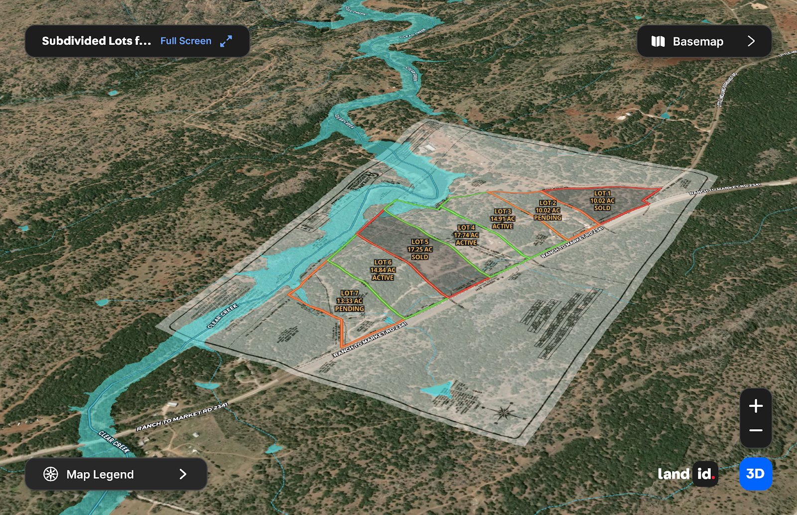
Subdivision Survey
Dividing your property into smaller lots for development? A subdivision survey defines the boundaries of each new lot and ensures they comply with local zoning regulations. This survey is crucial for ensuring the legality and feasibility of your subdivision project.
Floodplain Survey
A floodplain survey is essential if your property is in a flood-prone area. It identifies your flood zone and any potential risks associated with flooding. This information is crucial for insurance purposes and helps determine building restrictions in floodplains. Knowing your flood zone helps you make informed decisions about construction projects and ensures you're adequately covered by flood insurance.
How Much Does a Property Survey Cost?
The price tag for a property survey can vary depending on several factors:
- Size and Complexity of the Property: Extensive properties with intricate features like slopes or easements naturally cost more to survey than a simple, rectangular lot. The more intricate the property, the more time and effort the surveyor will need, translating to a higher cost.
- Type of Survey: As you might expect, complex surveys like ALTA/NSPS land title surveys or topographical surveys involve more detailed work and incur higher fees than basic boundary surveys. The level of detail and precision required in the survey directly impacts the cost.
- Location: Survey costs can fluctuate based on your geographic location. Areas with a higher cost of living often see corresponding increases in surveyor fees. It's always wise to get quotes from several licensed surveyors in your area to compare rates.
Here's a ballpark estimate of what you can expect to pay for different types of property surveys:
- Boundary Survey: This most common survey typically starts around $300 though depending on the factors mentioned above, prices can reach up to $1,000.
- Mortgage Survey: A simpler version of a boundary survey, mortgage surveys generally cost between $450 and $600. The exact cost depends on the complexity of the property and your lender's specific requirements.
- As-Built Survey: Depending on the size and complexity of the structures being documented, an as-built survey will cost between $750 and $1,400.
- New Construction Survey: The cost for a new construction survey can vary significantly based on the property size and project complexity. I can range from $1,500 to $3,000.
- Topographic Survey: Due to the detailed nature of this survey, topographic surveys can range from $400 to $1,500, depending on the size and complexity of the property.
- ALTA/NSPS Land Title Survey: These surveys are the most comprehensive and cost the most, ranging from $1,200 to $4,000 or even higher for highly complex properties.
Remember, these are just estimates. The best way to determine the exact cost for your specific needs is to contact a professional land surveyor in your area and request quotes for the survey you need.
How To Obtain a Property Survey
Obtaining a property survey is a crucial step when buying, selling, or renovating real estate. This process helps define the boundaries, rights, and restrictions of a property, ensuring all parties involved are clear about its specifics. Whether you're securing financing, resolving disputes, or simply ensuring compliance with local regulations, understanding how to obtain a property survey can provide peace of mind and legal clarity.
Finding a property survey can be approached in a few different ways:
- Contact a Licensed Land Surveyor: This is the most traditional route. Licensed surveyors possess the expertise and legal authorization to conduct accurate property surveys. Look for surveyors in good standing with your state licensing board.
- Check Local Government Offices: Municipalities and the local tax assessor's office might have existing surveys on file for your property, especially if it's part of a recorded subdivision.
- Consult Your Title Company: The title company involved in your real estate transaction might have a copy of a previous survey on file, though it's not guaranteed.
- Request from the Previous Owner: If you're buying property, you can ask the seller if they have a recent survey available.
- Look in the Property Deed: The legal description of your property in the deed might reference a specific survey, but the actual survey document might not be included.
- Utilize Online Resources: These tools streamline the initial phases of surveying by providing easy access to essential data. Land id® offers a user-friendly platform to access valuable property data, including property boundaries and ownership information, and can be a helpful resource for initial research and planning purposes.
- Engage a Real Estate Agent: If you're working with a real estate agent during a property transaction, they can guide you through the process of obtaining a property survey. A good real estate agent will talk to you about your needs and recommend the right type of survey, whether you're buying, selling, renovating, or settling a boundary issue.
Secure Your Investment With Land id®
Having a current and accurate property survey brings immense value to any real estate venture. It empowers you to make informed decisions, protect your investment, and ensure peace of mind.
Land id® stands as a valuable resource in your property ownership journey by helping you:
- Conduct Initial Research and Planning: Land id® offers a user-friendly platform to access valuable property data, including property boundaries and ownership information. This information can be a helpful starting point for your planning stages.
- Visualize Your Property: The interactive mapping tools allow you to visualize your property clearly and informatively. This can be particularly helpful for understanding your land's general layout, dimensions, topography, and surrounding features.
Sign up for a 7-day free trial of Land id® today and see how it can help you secure your real estate investment!
FAQs
Continue Reading
Alyssa Toohey
Off the Map & In Person: The Land id Team Gets Together

By Land id
The Land id team came together in Montana for collaboration, connection, Big Sky views, PBR, Yellowstone, and plenty of memorable moments.

How Land id Works for Residential Agents
By Land id
Learn how Land id helps residential real estate agents visualize location, uncover property context, and market listings with greater impact.


Explore Private Parcel Data & Property Boundaries
Download the Land id app and try for free.
