


You drove an hour and a half to show a buyer a property. Maybe two hours. You pulled up, walked the first 200 yards, and within five minutes, you knew.
The creek they loved in the photos? Seasonal. The flat buildable area? Half of it sits in a floodplain. The acreage they thought was usable? A third of it is wetlands.
The showing was over before it started. And you just burned half a day.
This isn't a buyer problem. It's a workflow problem. And it's one of the most fixable inefficiencies in real estate.
The Real Cost of the Wrong Showing
Time is the one thing you can't get back. For agents working properties with land, or showing properties outside of your territory, the math gets brutal fast.
A land or ranch agent might drive four-plus hours to a showing. A commercial agent vetting a transitional site might spend a full morning on a property that fails a basic buildability check. A residential agent with a buyer who's "open to acreage" can burn an entire week showing properties that don't actually fit.
The problem isn't that buyers send you bad leads. It's that you don't have a fast, reliable way to pre-qualify a property before committing to the drive.
Land id changes that. In 15 minutes at your desk, you can know more about a property than most agents learn from an in-person visit.
Who This Is For
This approach works for any agent who regularly shows properties where the land or surrounding context is part of the decision:
- Land and ranch agents who drive long distances and need to vet buyers and properties before making the trip
- Commercial agents evaluating transitional land, development sites, or rural parcels for investor clients
- Residential agents whose buyers are interested in acreage, creek frontage, views, or anything beyond a standard lot
In short, if you've ever driven an hour to a showing that could have been disqualified in a few minutes, this is for you.
I never go look at any property before I analyze it on Land id. This has saved me countless hours of driving as I already drive 40,000+ miles per year. When I am on property, the app helps tremendously as I know exactly where I am at all times.
—Loren Dickey
Start pre-qualifying properties today. Try Land id free for 7 days.
Pre-Showing Qualification Checklist
Before you schedule showings, use Land id to:
- Review all of the properties of interest.
- Confirm parcel boundaries and acreage.
- Check surrounding parcels and ownership context.
- Run for any deal-killers based on the buyer's goal (e.g., floodplain, wetlands, contour, soil overlays).
- Map your findings.
- Review your findings with the buyer to narrow down the properties worth touring.
- Schedule tours on qualified properties.
- Download the map for offline use before you leave cell range.
- On-site: Use the mobile app to navigate boundaries and features in real time.
Depending on your buyer’s priorities and number of properties, this desk review takes anywhere from 15 minutes to a couple of hours. The showings it saves you gives you back days and dollars.
The Desk Review: What to Check Before You Go
The goal isn't to replace the showing. It's to make sure the showing is worth having. Here's what to look at in Land id before you go.
Confirm the Basics

Listings tend to focus on a property’s positive aspects, leaving out details that might be dealbreakers. So before you get in the car, pull the parcel in Land id and look for anything that might stop the deal for your client. Verify the acreage, ownership, and boundaries. Confirm what's actually there before you build expectations around it.
No matter what kind of property you’re looking at, pull the surrounding parcels at the same time. Knowing the ownership and use context of adjacent land is often as important as the subject property itself, especially if part of the property's value is influenced by what's next door.
Check Out the “Deal-Killers” Overlays

This is the core of the desk review. Layer on the overlays that most commonly kill deals and look at them honestly:
- Floodplain: How much of the usable area is affected? Is the building site in the floodplain?
- Wetlands: Are there wetland designations that restrict use or development?
- Contours and slope: Is the terrain actually what the photos suggest? Steep slopes affect everything from buildability to access.
- Soil data: For agricultural or development properties, soil quality and drainage matter enormously.
- Access and energy: Are there transmission lines or substations that would impact development costs?
If a property fails two or three of these checks, there's a conversation to be had before you schedule the showing, not after you've driven out and back.
Send the Land id to Pre-Qualify

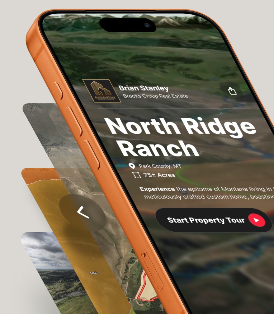
Before you go, share the Land id.
Save a map of the property with the relevant overlays. Add a waypoint or two to flag anything worth discussing. Then meet your buyers in the office to review and narrow down potential properties. Or faster yet, send the map link via text or email.
This does two things. First, it gives the buyer a real picture of the property story, not just a snapshot in time with listing photos. Second, it tells you something important about the buyer. A serious buyer will engage with the map and ask questions.
The moment you send that link and a buyer opens it on their phone and starts exploring the property, the dynamic shifts. You're not just an agent. You're the person who gave them data no one else did.
My buyers can view everything about the property online with docs and maps before setting foot on the ground. Land id saves time!
—Julie Mansfield Smith, Mossy Oak Properties Cupper Creek Land Company
On the Property: The Blue Dot Changes Everything

The desk review gets you to the showing. The Land id mobile app changes what happens when you get there.
Buyers often want to know what they can do with a piece of property. Being able to answer these questions on the fly is a huge differentiator. So pull up the Land id app on your phone when you arrive. The blue live-location dot places you precisely on the map in real time. As you walk the property, it moves with you.
For agents who work larger properties, this is not a small thing. You can walk a boundary line and watch the dot confirm exactly where you are. You can navigate to a specific feature, a creek crossing, a ridge line, or a potential building site without guessing. You can show a buyer exactly where the floodplain boundary falls relative to where they're standing.
If you’re touring a new development, pull up the geo-referenced site plan overlay on your phone and walk the actual footprint of the proposed development against the real terrain. That's a presentation, not just a showing.
It's one of those features that sounds simple until you use it on a 90-acre property in the dark timber and realize you actually know where you are. Buyers notice. They remember the agent who had that.
See Land id in action for yourself. Try it free for 7 days.
This is part two of our "Make the Most of Selling Season" series. Catch up with Part One here. Up next: Why your listings are invisible online, and how to fix it, fast.
FAQs
Catch Deal-Breakers Early
Save time and avoid expensive mistakes. Use Land id to evaluate deal-killing constraints before you leave your desk.
Continue Reading
Alyssa Toohey
Off the Map & In Person: The Land id Team Gets Together

By Land id
The Land id team came together in Montana for collaboration, connection, Big Sky views, PBR, Yellowstone, and plenty of memorable moments.

How Land id Works for Residential Agents
By Land id
Learn how Land id helps residential real estate agents visualize location, uncover property context, and market listings with greater impact.


Explore Private Parcel Data & Property Boundaries
Download the Land id app and try for free.
