


There's a moment every agent knows.
You're sitting across from a seller. The property has acreage, maybe some timber, a creek running through the back half. They've owned it for 30 years. They have a number in their head, and it's emotional, not mathematical.
You can feel the listing slipping before you've said a word.
The agents who win those appointments don't just know the property. They show up with something the seller has never seen before: a clear, visual story of what makes their property so special, what it's worth, and why you're the right person to sell it.
That's what this post is about
The Problem Isn't Preparation. It's the Kind of Preparation.
Many agents prep for listing appointments the same way. Pull the address. Check the tax record. Maybe look at a satellite image. Write down a few comps.
That's fine for a three-bedroom ranch house in a subdivision. It's not enough for a property where the land or amenities are part of the story.
When a property has acreage, topography, water features, or complex ownership history, the standard prep leaves you flat-footed. You're asking the seller questions you could have known the answer to. You're defending a price you can't fully explain. You're guessing at features you don’t fully understand
The agents who consistently win listings on these properties show up differently. They walk in with a map.
Who This Is For
This approach works for any agent who regularly encounters properties where the land matters:
- Land and ranch agents working larger acreage, rural properties, or recreational land
- Commercial agents presenting transitional land or development sites to investors and developers
- Residential agents with listings that have acreage, creek frontage, views, slopes, or anything a photo can't fully explain
If you're selling track homes in a flat subdivision, this probably isn't your moment. But if you've ever lost a listing because you couldn't tell the full story of a property, keep reading.
“As a land broker, I find that sellers who contact me to list their land often have never seen the land they own. So, they generally think it’s worth more than it is. I commonly send Land id maps to sellers, so that they can see the negative features of their land (e.g., steep slope, lack of access, remote location). This gives non-technology-oriented sellers confidence that I know where their land is, even though it has no address and I have not set foot on it. This also helps me to get the listing at a reasonable price where it will sell."
—Tammy Tengs, Land22 Real Estate
Start your free trial and build your first listing map before your next appointment. Try Land id Free.
Pre-Appointment Checklist
Before your next listing appointment on a property where the surrounding land matters, open up Land id to:
- Confirm parcel boundaries, acreage, and ownership record.
- Check the owner portfolio to see all parcels under the same owner.
- Visualize contours, floodplain, and relevant overlays.
- Pull comparable sales and note the ones that best support your price.
- Build the map and download for offline use if you're walking the property.
- Take your tablet to show the map while you’re walking the property
The whole process takes 10 to 20 minutes. The difference it makes in the room is huge.
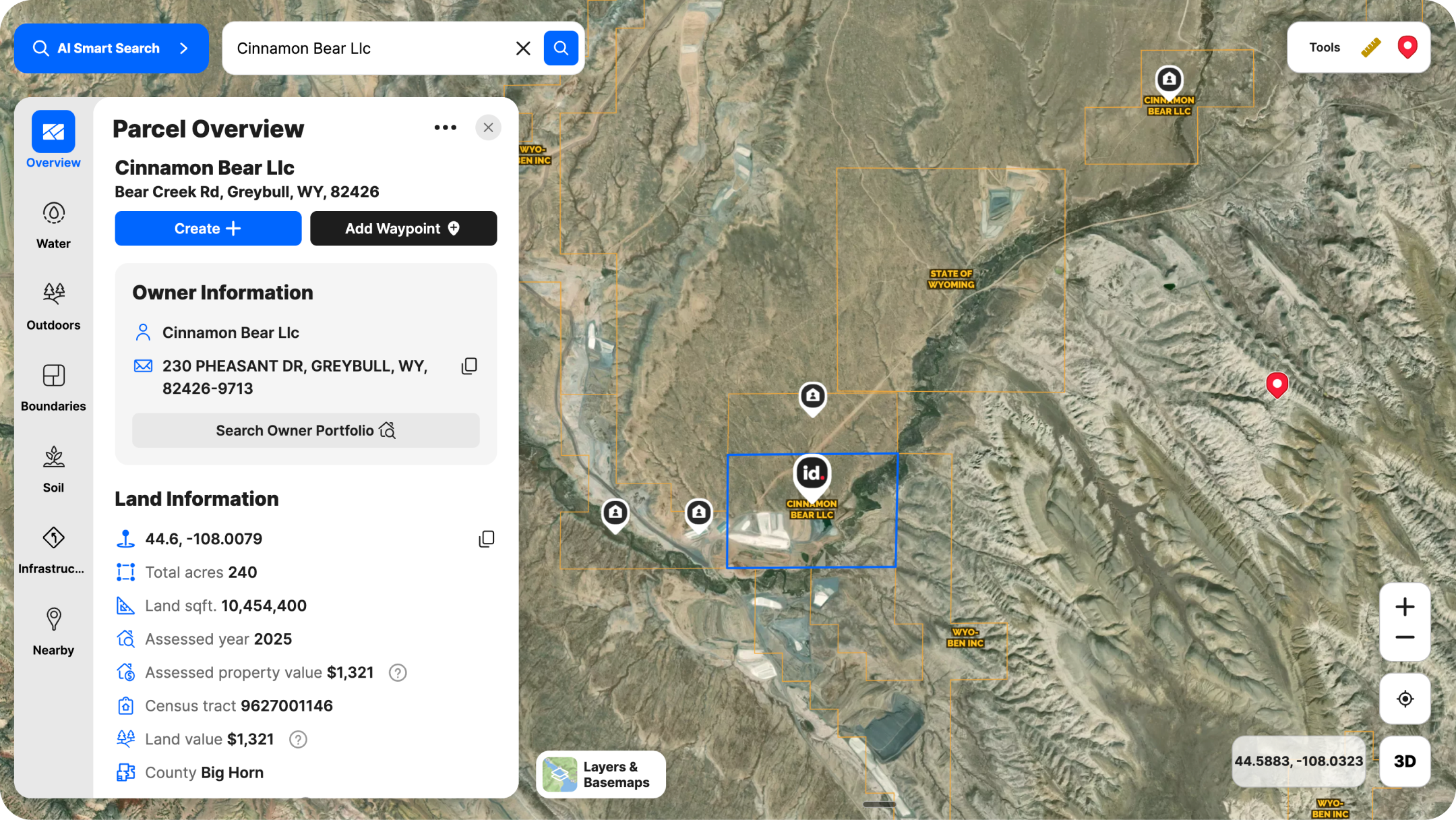
Pull the Property & Confirm the Basics
Start with the parcel card, where you’ll find all the basics:
- View the property boundary and ownership record.
- Confirm the acreage, the legal owner, and the tax history.
- For larger properties, check the owner portfolio to see whether there are multiple parcels under the same ownership that should be included in the listing.
This takes about two minutes and has saved more than a few agents from an awkward conversation at the table.
Pull the surrounding parcels too. Knowing who owns the adjacent land and what it's used for is the kind of detail that makes you look like the most informed person in the room.
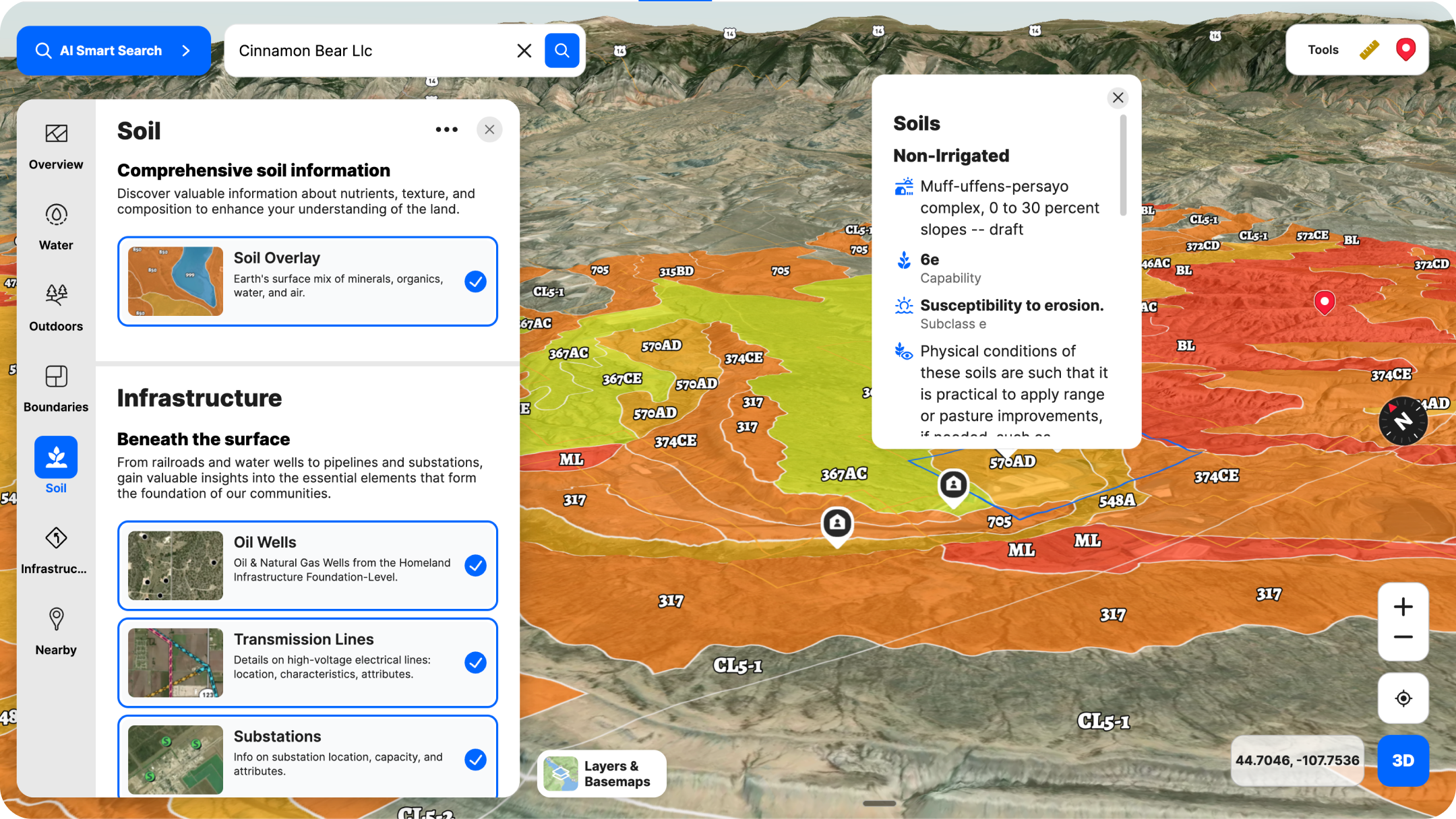
Layer on What Photos Don’t Show
This is where the appointment starts to shift in your favor. Add the overlays that tell the real story of the property:
- Contour lines to show elevation change and terrain
- Floodplain boundaries so you know what's buildable and what isn't
- Wetlands, if relevant
- Soil data for agricultural or development properties
- Water features: creeks, ponds, seasonal drainage
By doing this, you show your depth of understanding of their property and that you’re the right person to guide them through the process of pricing, marketing, and selling it. You're doing it so you can speak to every question they might raise and defend your pricing with something more than instinct.
Understand the Comparable Sales Picture
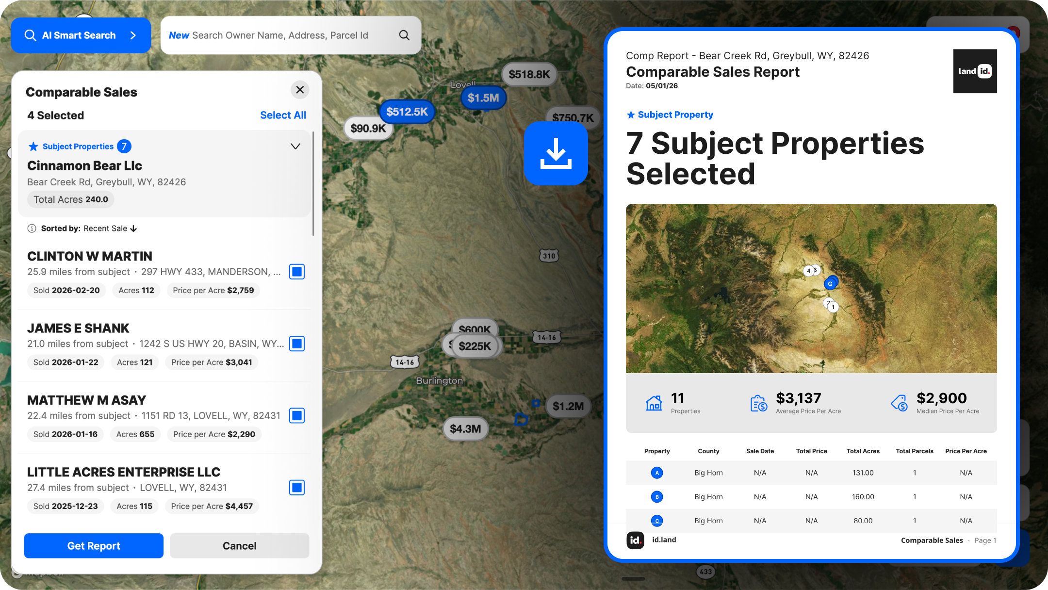
Pricing properties with acreage is hard. Comparable sales are fewer, more varied, and harder to compare directly. Sellers often come in with a number based on what their neighbor got three years ago for a different kind of property.
Land id's Comparable Sales Reports let you pull sales from the past 24 months and generate a polished, share-ready PDF, complete with property boundaries and aerial photos already included, in minutes. When a seller asks for your pricing recommendation, you have a recommendation backed up with visual proof. That's a different conversation entirely.
Your comparable sales data stays private. It's yours, and it doesn't get shared unless you choose to share it.
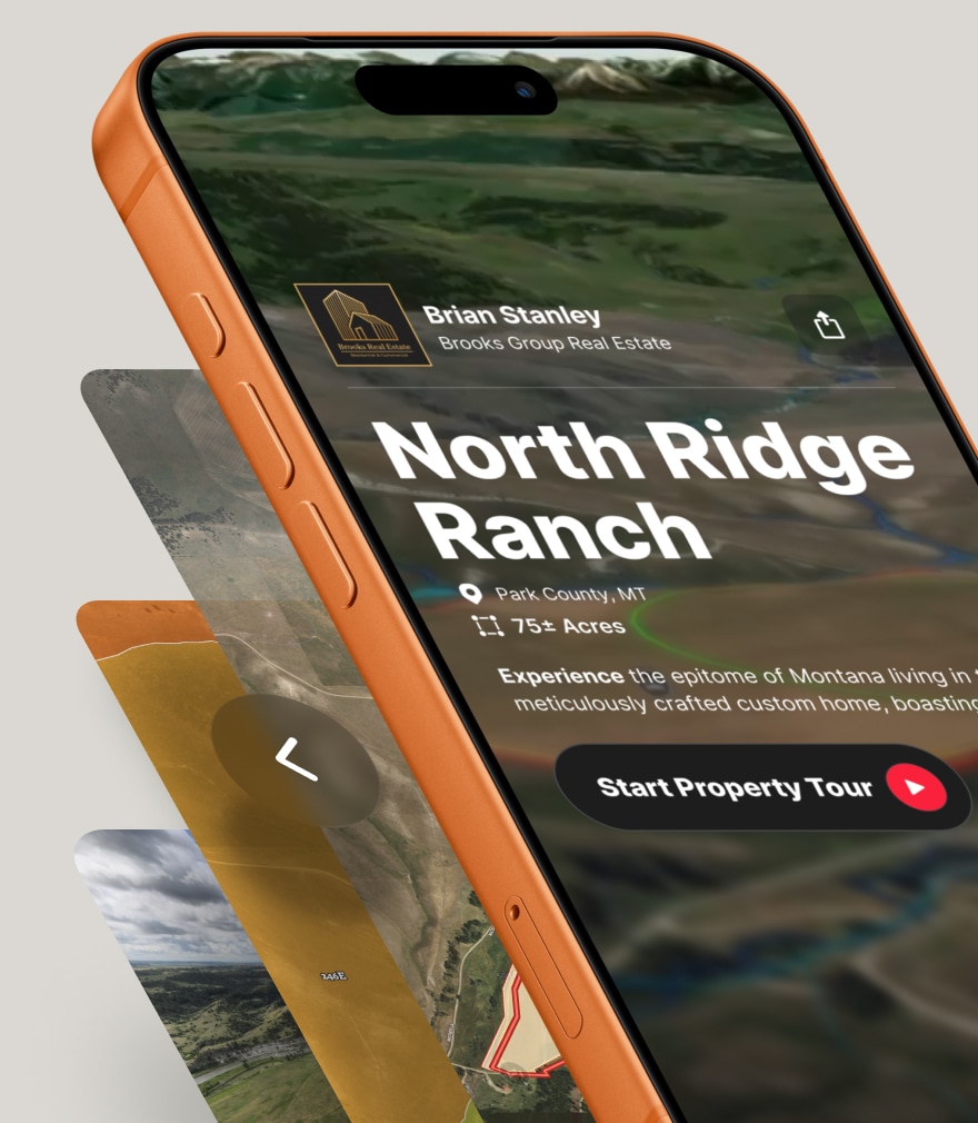
Be Ready to Show & Share the Map
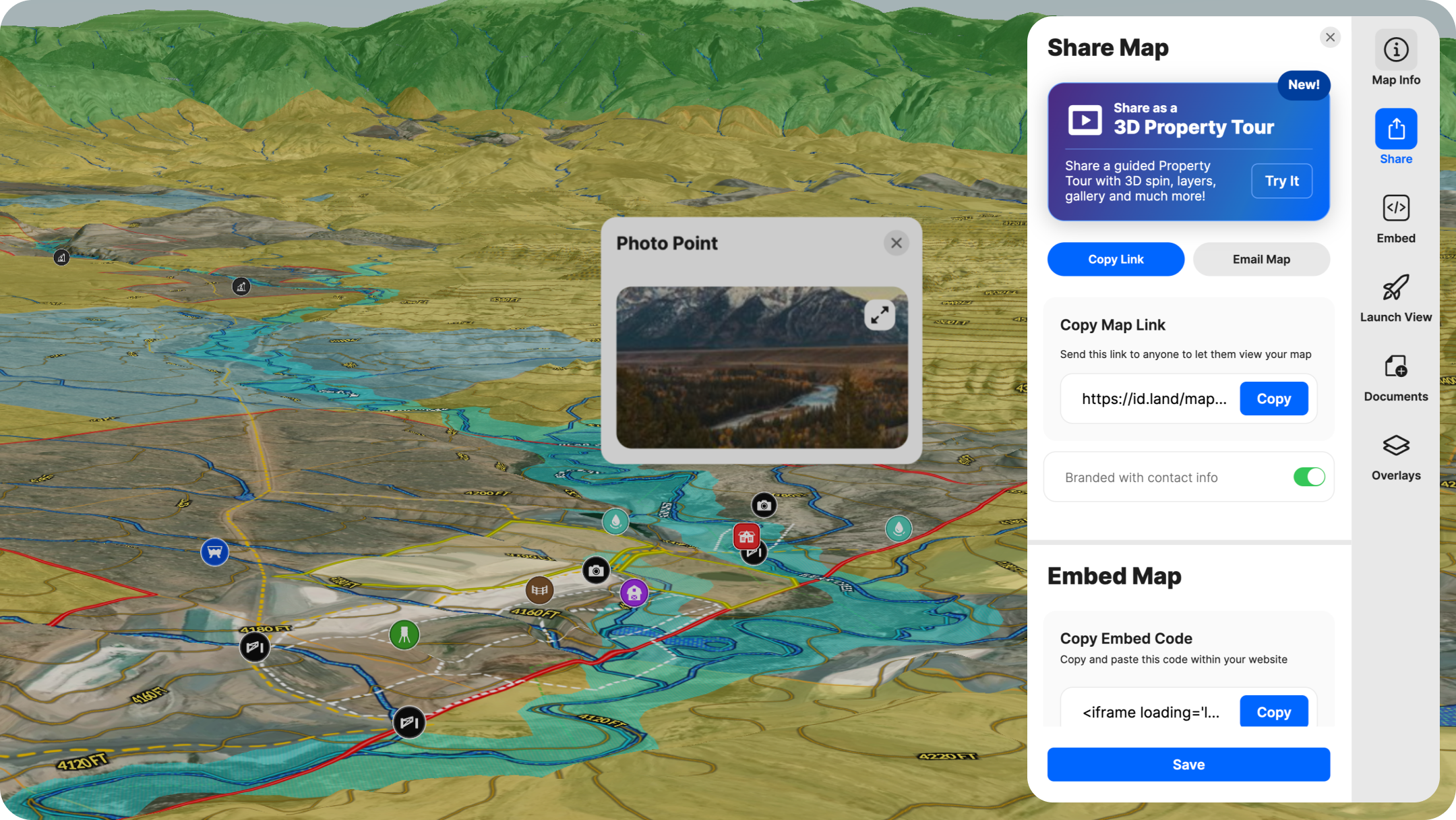
Here's a pro tip for listing appointments: Build the map before you meet and make it part of your pitch. More on that below. If you’re working with a potential buyer, share the map via text or email. The buyer sees the land laid out with real data, so they trust you’ve done your homework.
"An initial map doesn't need to be perfect. It's about showing the landowner that you’ve invested time in researching their property and inviting them to collaborate on finalizing the map."
—Harlan Ray, Burgher-Ray Ranch Group, Briggs Freeman Sotheby's International Realty
If you plan to walk the property, be sure to download your map for offline use, too.
During the Appointment
When you're in the room, the map isn't a prop. It's a communication tool.
Co-Create a Property Story
Pull Land id up on your laptop or tablet. Walk the seller through the property visually. Show them the terrain, the water, the boundaries. If there are features they're proud of, find them on the map and name them. If there are constraints they may not have fully considered, like a floodplain that affects a portion of the acreage, surface them now rather than letting a buyer discover them later.
Walk the Land in Real Time
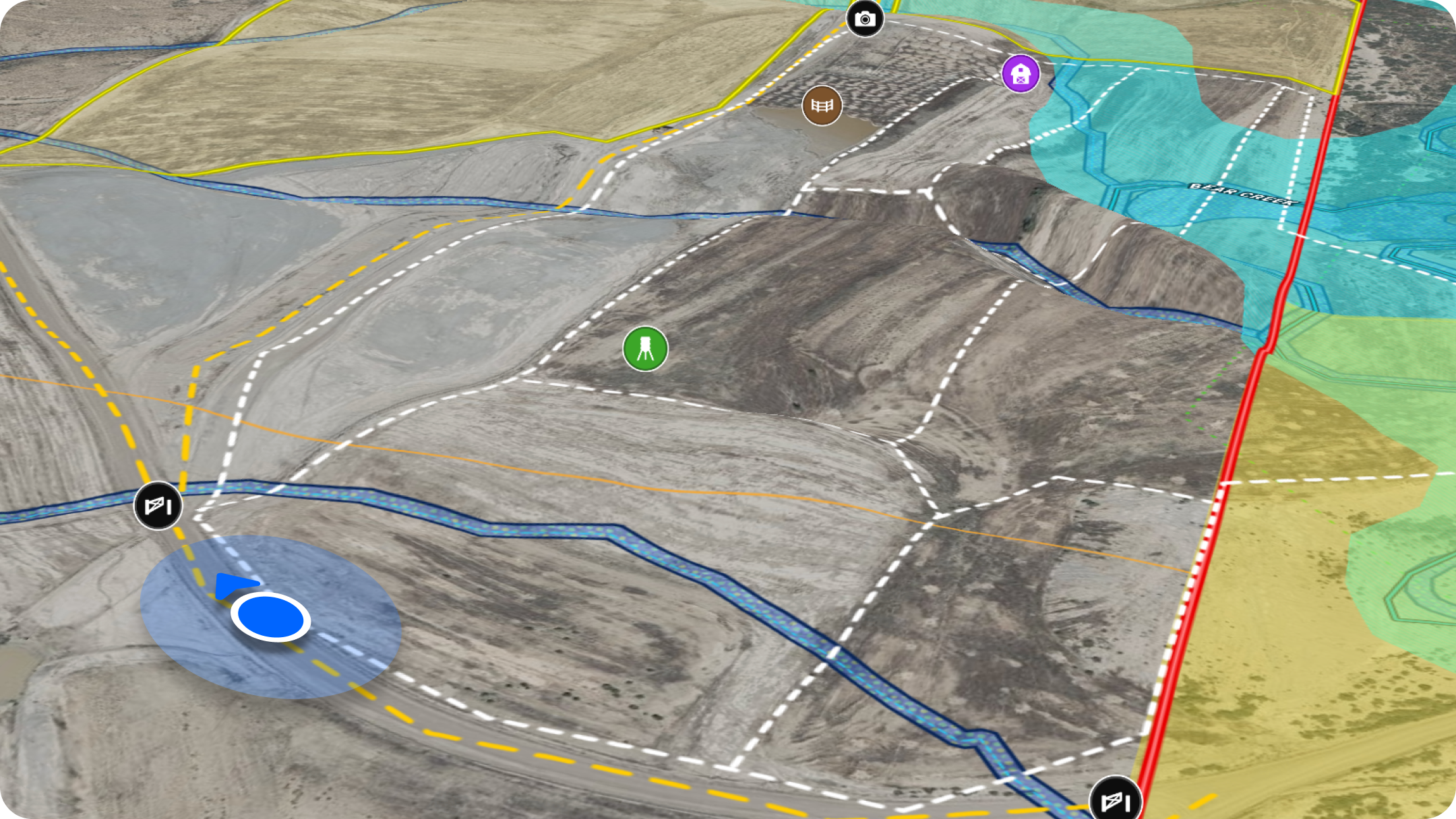
The Land id mobile app is invaluable. If the appointment includes a property walk, you can pull up the map on your phone and watch your “blue dot” location to navigate the actual boundary in real time. You're not guessing where the property line is. You're standing on it.
If you're talking about dividing or subdividing a site, this is the moment to show the geo-referenced plat or site plan. Drop the drawing directly onto the map and let the client see exactly how the site lays out against the real parcel boundaries.
After the Appointment
Stick the landing with a few quick follow-ups:
- Send a link to the map.
- Send a PDF of the comparable sales report.
- For listing appointments, send a recap of your meeting, including projects/improvements you recommend to prepare their property for listing.
FAQs
Bring Property Stories to Life With Land id
Deliver custom virtual property tours in minutes. Surface unique property data, craft a visually compelling story, and help clients make decisions faster.
Continue Reading
Craig Rowe
How Factory-Built Housing Can Reshape America’s Housing Market
.png)
By Land id
The U.S. housing industry’s decade-plus-long inventory challenge could see its first true sign of resolution should the 21st Century Road to Housing Act become law.

Craig Rowe
Can Refurbishing Schools Help Solve Housing Issues?
By Land id
Old public schools are becoming apartments as enrollment drops. See why school-to-apartment conversion is adaptive reuse's fastest-growing niche.


Explore Private Parcel Data & Property Boundaries
Download the Land id app and try for free.
